IMAGES TAKEN NEAR TO
Glenwell Road, NEWTOWNABBEY, BT36 7RF
Introduction
This page details the photographs taken nearby to Glenwell Road, BT36 7RF by members of the Geograph project.
The Geograph project started in 2005 with the aim of publishing, organising and preserving representative images for every square kilometre of Great Britain, Ireland and the Isle of Man.

There are currently over 7.5m images from over14,400 individuals and you can help contribute to the project by visiting https://www.geograph.org.uk
Image Map
Images are licensed for reuse under creativecommons.org/licenses/by-sa/2.0
Notes
- Clicking on the map will re-center to the selected point.
- The higher the marker number, the further away the image location is from the centre of the postcode.
Image Listing (15 Images Found)
Images are licensed for reuse under creativecommons.org/licenses/by-sa/2.0
Image
Details
Distance
1
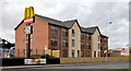
288 Antrim Road, Glengormley (1)
A development of 18 apartments, currently offered for sale, on the western side of the Antrim Road near Church Way. This photograph appears as a matter of geographical and historical record only. I have no connection with any of the parties involved in the development and sale. See also Image
Image: © Albert Bridge
Taken: 24 Mar 2014
0.04 miles
2
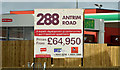
288 Antrim Road, Glengormley (2)
See Image The joint agents’ “for sale” board facing the Antrim Road. This photograph appears as a matter of geographical and historical record only. I have no connection with any of the parties involved in the development and sale. To avoid any possible misunderstanding, the internet advertising (at the date of submission) for this development makes it very clear that the price shown applies to one one-bedroom apartment only.
Image: © Albert Bridge
Taken: 24 Mar 2014
0.04 miles
3
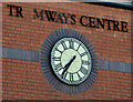
Clock, Glengormley
A clock (not working) at the Tramways Centre Image on the Antrim Road.
Image: © Albert Bridge
Taken: 28 Sep 2012
0.07 miles
4
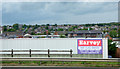
Glengormley from the M2 motorway
A wide range of building types and architectural styles on view here.
Image: © Thomas Nugent
Taken: 1 Jun 2019
0.07 miles
5
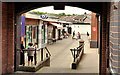
The Tramways Centre, Glengormley
A small suburban shopping development, anchored by Iceland (right), on the south western side of the Antrim Road. It takes its name from the old (independent) Cavehill and Whitewell Tramway. The line, initially horse and later steam-operated, opened in 1882. Electrified in 1906 and absorbed into the municipal system in 1911, it closed in 1949.
Image: © Albert Bridge
Taken: 29 May 2012
0.10 miles
6
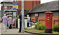
Pillar box, Glengormley (1-1)
See Image The box (BT36 514) still has the remains of the bracket once used to hold a sign pointing to the nearest post office.
Image: © Albert Bridge
Taken: 29 May 2012
0.11 miles
7
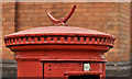
Pillar box, Glengormley (1-2)
See Image The box (BT36 514) still has the remains of the bracket once used to hold a sign pointing to the nearest post office.
Image: © Albert Bridge
Taken: 29 May 2012
0.11 miles
8
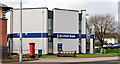
The Ulster Bank, Glengormley
The Glengormley branch of the Ulster Bank on the Antrim Road, at the corner of Farmley Road. The satellite photograph shows that it’s octagonal.
Image: © Albert Bridge
Taken: 24 Mar 2014
0.12 miles
9
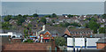
Glengormley from the M2 motorway
An over the rooftops view of the town centre.
Image: © Thomas Nugent
Taken: 1 Jun 2019
0.13 miles
10
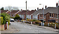
Church Crescent, Glengormley
A street, off Church Way and the Antrim Road. It could be called typical Glengormley in two respects – semi-detached houses and, at a height of almost 500ft, views over Belfast Lough (background).
Image: © Albert Bridge
Taken: 24 Mar 2014
0.15 miles