IMAGES TAKEN NEAR TO
Church Road, NEWTOWNABBEY, BT36 7LG
Introduction
This page details the photographs taken nearby to Church Road, BT36 7LG by members of the Geograph project.
The Geograph project started in 2005 with the aim of publishing, organising and preserving representative images for every square kilometre of Great Britain, Ireland and the Isle of Man.

There are currently over 7.5m images from over14,400 individuals and you can help contribute to the project by visiting https://www.geograph.org.uk
Image Map
Images are licensed for reuse under creativecommons.org/licenses/by-sa/2.0
Notes
- Clicking on the map will re-center to the selected point.
- The higher the marker number, the further away the image location is from the centre of the postcode.
Image Listing (3 Images Found)
Images are licensed for reuse under creativecommons.org/licenses/by-sa/2.0
Image
Details
Distance
1
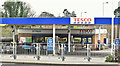
Tesco petrol station, Newtownabbey (January 2017)
A 24-hour Tesco petrol station at the Abbey Retail Park, Church Road.
Image: © Albert Bridge
Taken: 18 Jan 2017
0.17 miles
2
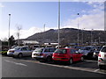
The Cave Hill from the Abbeycentre
The Cave Hill seen on a sunny January morning from outside Marks & Spencer's on Longwood Road, Newtownabbey.
Image: © Dean Molyneaux
Taken: 30 Jan 2010
0.19 miles
3
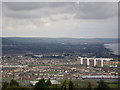
Rathcoole Overview.
Shows Rathcoole from Belfast Zoo and the four huge, striking, landmark multi-storey flats.
Image: © John Pollock
Taken: 27 Mar 2005
0.24 miles