IMAGES TAKEN NEAR TO
Glenhurst Parade, NEWTOWNABBEY, BT36 7JR
Introduction
This page details the photographs taken nearby to Glenhurst Parade, BT36 7JR by members of the Geograph project.
The Geograph project started in 2005 with the aim of publishing, organising and preserving representative images for every square kilometre of Great Britain, Ireland and the Isle of Man.

There are currently over 7.5m images from over14,400 individuals and you can help contribute to the project by visiting https://www.geograph.org.uk
Image Map
Images are licensed for reuse under creativecommons.org/licenses/by-sa/2.0
Notes
- Clicking on the map will re-center to the selected point.
- The higher the marker number, the further away the image location is from the centre of the postcode.
Image Listing (4 Images Found)
Images are licensed for reuse under creativecommons.org/licenses/by-sa/2.0
Image
Details
Distance
1
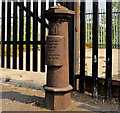
Old boundary post, Whitewell, Belfast (1)
An old Belfast municipal boundary post, on the Whitewell Road, opposite Voltaire Gardens. Image shows the inscription.
Image: © Albert Bridge
Taken: 25 May 2012
0.21 miles
2
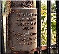
Old boundary post, Whitewell, Belfast (2)
See Image The inscription “Parliamentary and Municipal Boundary of Belfast Duncairn Division Duncairn Ward 1918”. Similar to this one Image but in another ward.
Image: © Albert Bridge
Taken: 25 May 2012
0.21 miles
3
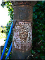
Boundary Post, Belfast
An old Belfast boundary post located on the Antrim Road, directly across the road from Image This post would have had the same inscription but the plaque bearing this has been removed. Interestingly, this gives a glimpse behind and shows that there is another (possibly earlier) inscription which reads "Parliamentary Boundary of Borough of" - the rest has been removed. A boundary post is shown at this location on OS maps dating from 1901 - it may have been this one with the earlier inscription and a plate was simply added to it when the ward boundaries were changed in 1918.
Image: © Rossographer
Taken: 28 Jun 2011
0.24 miles
4
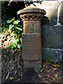
Boundary Post, Belfast
An old Belfast boundary post located on the Antrim Road.
The inscription reads
"Parliamentary
and Municipal Boundary of
Belfast
Duncairn Division
Clifton Ward
1918".
Image: © Rossographer
Taken: 28 Jun 2011
0.25 miles