IMAGES TAKEN NEAR TO
Felden Close, NEWTOWNABBEY, BT36 7FH
Introduction
This page details the photographs taken nearby to Felden Close, BT36 7FH by members of the Geograph project.
The Geograph project started in 2005 with the aim of publishing, organising and preserving representative images for every square kilometre of Great Britain, Ireland and the Isle of Man.

There are currently over 7.5m images from over14,400 individuals and you can help contribute to the project by visiting https://www.geograph.org.uk
Image Map
Images are licensed for reuse under creativecommons.org/licenses/by-sa/2.0
Notes
- Clicking on the map will re-center to the selected point.
- The higher the marker number, the further away the image location is from the centre of the postcode.
Image Listing (7 Images Found)
Images are licensed for reuse under creativecommons.org/licenses/by-sa/2.0
Image
Details
Distance
1
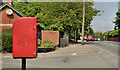
Letter box, Felden, Newtownabbey
Post-mounted EIIR letter box (BT36 285), at Old Mill Drive on the Mill Road, close to the former Felden Mill and Skills Centre.
Image: © Albert Bridge
Taken: 25 May 2012
0.12 miles
2
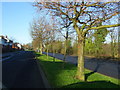
Whitewell Road
View along Whitewell Road near to White City looking North.
Image: © Gary Thompson
Taken: 8 Jan 2009
0.17 miles
3
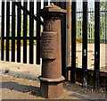
Old boundary post, Whitewell, Belfast (1)
An old Belfast municipal boundary post, on the Whitewell Road, opposite Voltaire Gardens. Image shows the inscription.
Image: © Albert Bridge
Taken: 25 May 2012
0.18 miles
4
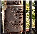
Old boundary post, Whitewell, Belfast (2)
See Image The inscription “Parliamentary and Municipal Boundary of Belfast Duncairn Division Duncairn Ward 1918”. Similar to this one Image but in another ward.
Image: © Albert Bridge
Taken: 25 May 2012
0.18 miles
5
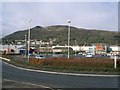
Retail Park
At Whiteabbey with The Cave Hill in the background.Image
Image: © Paul McIlroy
Taken: 13 Apr 2006
0.18 miles
6
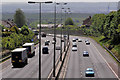
The M2 (hill section), Belfast (4)
See Image The view towards Belfast from the same bridge.
Image: © Albert Bridge
Taken: 6 May 2011
0.18 miles
7
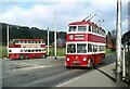
Belfast Trolleybus 210 leaving Whitewell terminus - 1968
This was the northern terminal point of the last remaining trolleybus route in Belfast, running across city to Falls Road and would cease operation 4 weeks after my visit. The turning loop still exists but is no longer used by buses.
The trolleybus is a BUT 9641T with locally built Harkness bodywork, built in 1950.
This is one of a series of views featuring buses in the 60s, 70s, and 80s. http://www.geograph.org.uk/search.php?i=137652761
Image: © Alan Murray-Rust
Taken: 14 Apr 1968
0.25 miles