IMAGES TAKEN NEAR TO
Burneys Lane, NEWTOWNABBEY, BT36 7AD
Introduction
This page details the photographs taken nearby to Burneys Lane, BT36 7AD by members of the Geograph project.
The Geograph project started in 2005 with the aim of publishing, organising and preserving representative images for every square kilometre of Great Britain, Ireland and the Isle of Man.

There are currently over 7.5m images from over14,400 individuals and you can help contribute to the project by visiting https://www.geograph.org.uk
Image Map
Images are licensed for reuse under creativecommons.org/licenses/by-sa/2.0
Notes
- Clicking on the map will re-center to the selected point.
- The higher the marker number, the further away the image location is from the centre of the postcode.
Image Listing (3 Images Found)
Images are licensed for reuse under creativecommons.org/licenses/by-sa/2.0
Image
Details
Distance
1
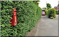
Letter box, Glengormley
Post-mounted EIIR letter box (BT36 622) at Moyola Park on the Antrim Road.
Image: © Albert Bridge
Taken: 29 May 2012
0.22 miles
2
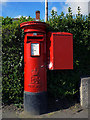
Postbox near Glengormley
Elizabeth II postbox located on the A6 Antrim Road near the Sandyknowes roundabout.
Image: © Rossographer
Taken: 28 Jun 2011
0.25 miles
3
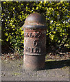
Milepost near Glengormley
Old milepost located on the A6 Antrim Road close to Sandyknowes roundabout. It simply states that Belfast is 6 miles away - no other destinations are mentioned. Mileposts from Belfast were measured from the "Four Corners" at the junction of Waring Street, North Street, Donegall Street and Bridge Street, a site later occupied by the Exchange and Assembly Rooms Image; see Image for a plaque on the building explaining this.
Image: © Rossographer
Taken: 28 Jun 2011
0.25 miles