IMAGES TAKEN NEAR TO
Woodford Road, NEWTOWNABBEY, BT36 6TS
Introduction
This page details the photographs taken nearby to Woodford Road, BT36 6TS by members of the Geograph project.
The Geograph project started in 2005 with the aim of publishing, organising and preserving representative images for every square kilometre of Great Britain, Ireland and the Isle of Man.

There are currently over 7.5m images from over14,400 individuals and you can help contribute to the project by visiting https://www.geograph.org.uk
Image Map
Images are licensed for reuse under creativecommons.org/licenses/by-sa/2.0
Notes
- Clicking on the map will re-center to the selected point.
- The higher the marker number, the further away the image location is from the centre of the postcode.
Image Listing (6 Images Found)
Images are licensed for reuse under creativecommons.org/licenses/by-sa/2.0
Image
Details
Distance
1
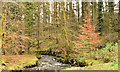
The Three Mile Water, Newtownabbey - March 2014(2)
A bend in the Three Mile Water, as it flows through conifers, downstream from here Image The Doagh Road is at the top of the steep bank on the right.
Image: © Albert Bridge
Taken: 19 Mar 2014
0.18 miles
2
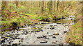
The Three Mile Water, Newtownabbey - March 2014(3)
The wooded banks of the Three Mile Water, looking upstream towards here Image
Image: © Albert Bridge
Taken: 19 Mar 2014
0.19 miles
3
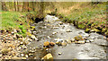
The Three Mile Water, Newtownabbey - March 2014(1)
The low Three Mile Water, looking downstream, from close to the Doagh Road bridge Image
Image: © Albert Bridge
Taken: 19 Mar 2014
0.21 miles
4
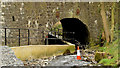
The Three Mile Water bridge, Doagh Road, Newtownabbey
The Three Mile Water, looking downstream, as it flows under the Doagh Road in the Three Mile Water Park. The path is a continuation of this ramp Image
Image: © Albert Bridge
Taken: 19 Mar 2014
0.22 miles
5
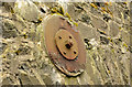
Bridge reinforcing, Newtownabbey
Reinforcing on the upstream side of this bridge Image There is no equivalent on the downstream side.
Image: © Albert Bridge
Taken: 19 Mar 2014
0.22 miles
6
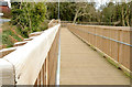
Access ramp, Three Mile Water Park, Newtownabbey
A wooden access ramp, suitable for wheelchairs and those with restricted mobility, leading from the Manse Road (left), under the Doagh Road, to the Three Mile Water Park.
Image: © Albert Bridge
Taken: 19 Mar 2014
0.23 miles