1
No 79 Carnmoney Road, Newtownabbey (February 2017)
Currently vacant premises advertised for sale. The agents’ description includes “The subject property comprises a two storey, detached property with adjoining lean-to rear and side stores totalling c. 1,722 sq ft. The property is in reasonable condition throughout and would be suitable for either owner occupation or redevelopment, subject to all necessary statutory consents. The building is situated on a total site area of approximately 0.15 acres”. Previously used by a wholesale stationer. The photograph appears as a matter of record only. I have no involvement in the sale.
Image: © Albert Bridge
Taken: 22 Feb 2017
0.04 miles
2
Headstones, Carnmoney Cemetery, Newtownabbey (February 2017)
Headstones, on graves, on the southern side of the Church Road. The inscriptions are in Hebrew and English http://www.jewishgen.org/jcr-uk/Community/belfast.htm
Image: © Albert Bridge
Taken: 22 Feb 2017
0.07 miles
3
Carnmoney Church Graveyard
Old Church graveyard at Carnmoney Church of Ireland on Church Road.
Image: © Gary Thompson
Taken: 8 Jan 2009
0.11 miles
4
Carnmoney Church of Ireland
Situated on Church Road Newtownabbey.
Image: © Gary Thompson
Taken: 17 Jan 2009
0.11 miles
5
James Cuming headstone, Carnmoney CoI graveyard, Newtownabbey (February 2017)
A headstone with the inscription “Here Lyeth ye body of James Cuming who died Jully ye 10 1742 aged 20 years”.
Image: © Albert Bridge
Taken: 22 Feb 2017
0.12 miles
6
Cast grave markers, Carnmoney CoI graveyard, Newtownabbey (February 2017)
Cast grave markers, in the style of those made by the Millfield Foundry (tag at bottom right) on the graves of James and Samuel Russel (left) and Mary Russel.
Image: © Albert Bridge
Taken: 22 Feb 2017
0.12 miles
7
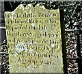
Edward Brice headstone, Carnmoney CoI graveyard, Newtownabbey (February 2017)
A headstone in that elaborate style common in the mid-18th century. The inscription reads “Here Lieth the Remains of Edward Brice who Departed this Life 9th March 1787 aged 70 yrs and Also his wife Jane McCuick [?] who Depd this Life in April 1761 Aged 40 years”.
Image: © Albert Bridge
Taken: 22 Feb 2017
0.12 miles
8
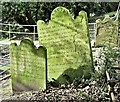
Dunlap/Dunlop headstones, Carnmoney CoI graveyard, Newtownabbey (February 2017)
Two headstones marking the graves of members of the Dunlop family who died on various dates between 1805 and 1886. The spelling “Dunlap”, originally used, later became “Dunlop”. The former pronunciation remained in use well into the late 20th century.
Image: © Albert Bridge
Taken: 22 Feb 2017
0.12 miles


