IMAGES TAKEN NEAR TO
Ballynure Road, NEWTOWNABBEY, BT36 5SJ
Introduction
This page details the photographs taken nearby to Ballynure Road, BT36 5SJ by members of the Geograph project.
The Geograph project started in 2005 with the aim of publishing, organising and preserving representative images for every square kilometre of Great Britain, Ireland and the Isle of Man.

There are currently over 7.5m images from over14,400 individuals and you can help contribute to the project by visiting https://www.geograph.org.uk
Image Map
Images are licensed for reuse under creativecommons.org/licenses/by-sa/2.0
Notes
- Clicking on the map will re-center to the selected point.
- The higher the marker number, the further away the image location is from the centre of the postcode.
Image Listing (1 Images Found)
Images are licensed for reuse under creativecommons.org/licenses/by-sa/2.0
Image
Details
Distance
1
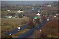
The Larne line near Ballyhenry
The “Larne line” has nothing to do with railways. It is the local name for the section of the Belfast-Larne road north of Glengormley. This is the view from Corr’s Corner roundabout to Coleman’s Corner roundabout with Houston’s Corner roundabout in the middle. (There are another five roundabouts before the road reaches Larne harbour!!). (Note: the grid line runs very close to the middle of the central reservation . . . .).
Image: © Albert Bridge
Taken: 21 Dec 2006
0.16 miles