IMAGES TAKEN NEAR TO
Crescent Corner, NEWTOWNABBEY, BT36 5PB
Introduction
This page details the photographs taken nearby to Crescent Corner, BT36 5PB by members of the Geograph project.
The Geograph project started in 2005 with the aim of publishing, organising and preserving representative images for every square kilometre of Great Britain, Ireland and the Isle of Man.

There are currently over 7.5m images from over14,400 individuals and you can help contribute to the project by visiting https://www.geograph.org.uk
Image Map
Images are licensed for reuse under creativecommons.org/licenses/by-sa/2.0
Notes
- Clicking on the map will re-center to the selected point.
- The higher the marker number, the further away the image location is from the centre of the postcode.
Image Listing (29 Images Found)
Images are licensed for reuse under creativecommons.org/licenses/by-sa/2.0
Image
Details
Distance
1
Pillar box, Mossley, Newtownabbey
EIIR pillar box (BT36 512) outside the former post office at The Glade. Mossley West station Image is just out of picture (right).
Image: © Albert Bridge
Taken: 9 Jun 2012
0.01 miles
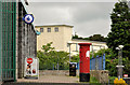
2
National Cycle Network sign, Mossley, Newtownabbey (December 2016)
National Cycle Network direction signs for route 93, at Carnmoney Road North, opposite the entrance to Mossley Mill the chimney of which Image is in the right background.
Image: © Albert Bridge
Taken: 31 Dec 2016
0.02 miles
3
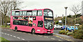
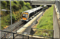
Bus, Mossley West station, Newtownabbey (December 2016)
Metro Wright-bodied Volvo (2350 SEZ 2350) awaiting departure from Mossley West station with the 11.17 1D to Donegall Place (41 minutes).
Image: © Albert Bridge
Taken: 31 Dec 2016
0.03 miles
4
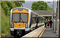
Train, Mossley West, Newtownabbey
See Image The same train calling at Mossley West station.
Image: © Albert Bridge
Taken: 9 Jun 2012
0.03 miles
5
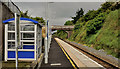
Mossley West station, Newtownabbey (1)
Mossley West station opened in 2001 as part of the restoration of passenger services to the Bleach Green – Antrim line. In a cutting off the Carnmoney Road North, close to the Doagh Road, access is not easy. It was improved in 2008 to provide better access for the disabled. This view shows the 09.11 Belfast Gt Victoria Street – Londonderry calling. The extensive ramps needed for wheelchairs etc are behind me. The former Mossley station Image was on a completely different site, on the Belfast side of here. Image shows the cutting on the Antrim side of the station.
Image: © Albert Bridge
Taken: 9 Jun 2012
0.03 miles
6
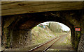
Road bridge, Mossley West station, Newtownabbey (2)
See Image The bridge from the platform.
Image: © Albert Bridge
Taken: 13 Mar 2014
0.04 miles
7
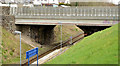
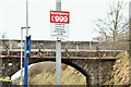
Road bridge, Mossley West station, Newtownabbey (1)
The widened Carnmoney Road North passing over the Belfast end of Mossley West station. The fence is just that bit too high for photography. Note the “6 car stop” sign at the very end of the platform (lower middle). Image shows the bridge from the platform.
Image: © Albert Bridge
Taken: 13 Mar 2014
0.04 miles
8
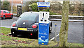
E-car charging point, Mossley, Newtownabbey (December 2016)
An e-car charging point at Mossley West station park and ride car park.
Image: © Albert Bridge
Taken: 31 Dec 2016
0.04 miles
9
Mossley West station, Newtownabbey (2)
See Image A platform-level view of the station and the cutting, looking towards Antrim
Image: © Albert Bridge
Taken: 9 Jun 2012
0.06 miles
10
"999" sign, Mossley West station, Newtownabbey (December 2016)
Now standard at NIR stations this one is on the platform at Mossley West. A short history of the number is available here https://en.wikipedia.org/wiki/999_(emergency_telephone_number).
Image: © Albert Bridge
Taken: 31 Dec 2016
0.06 miles