IMAGES TAKEN NEAR TO
Uppertown Drive, NEWTOWNABBEY, BT36 5NU
Introduction
This page details the photographs taken nearby to Uppertown Drive, BT36 5NU by members of the Geograph project.
The Geograph project started in 2005 with the aim of publishing, organising and preserving representative images for every square kilometre of Great Britain, Ireland and the Isle of Man.

There are currently over 7.5m images from over14,400 individuals and you can help contribute to the project by visiting https://www.geograph.org.uk
Image Map
Images are licensed for reuse under creativecommons.org/licenses/by-sa/2.0
Notes
- Clicking on the map will re-center to the selected point.
- The higher the marker number, the further away the image location is from the centre of the postcode.
Image Listing (19 Images Found)
Images are licensed for reuse under creativecommons.org/licenses/by-sa/2.0
Image
Details
Distance
1
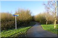
Newtownabbey Way
The Newtownabbey Way path at New Mossley, looking towards Corr's Corner. The signpost is for the National Cycle Network's route 93 which follows the Newtownabbey Way as part of its traffic-free route to Belfast, some 9 miles away in the other direction.
Image: © Robert Ashby
Taken: 20 Jan 2014
0.10 miles
3
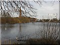
Former mill dam, Mossley, Newtownabbey
The western side of the old mill dam.
Image: © Albert Bridge
Taken: 9 Jun 2012
0.14 miles
4
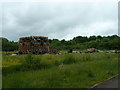
Loyalist bonfire
An embryo bonfire being constructed - well away from housing in this instance - in readiness for traditional 11th July Bonfire Night in loyalist areas of Northern Ireland as part of the Orange celebrations commemorating the Battle of the Boyne in 1690.
Image: © Robert Ashby
Taken: 1 Jul 2013
0.20 miles
5
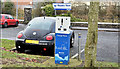
E-car charging point, Mossley, Newtownabbey (December 2016)
An e-car charging point at Mossley West station park and ride car park.
Image: © Albert Bridge
Taken: 31 Dec 2016
0.20 miles
6
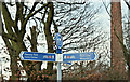
National Cycle Network sign, Mossley, Newtownabbey (December 2016)
National Cycle Network direction signs for route 93, at Carnmoney Road North, opposite the entrance to Mossley Mill the chimney of which Image is in the right background.
Image: © Albert Bridge
Taken: 31 Dec 2016
0.20 miles
7

Railway cutting, Mossley West, Newtownabbey
The 07.57 Londonderry – Belfast Gt Victoria Street (3021) passing through the deep cutting on the approach to Mossley West station Image
Image: © Albert Bridge
Taken: 9 Jun 2012
0.20 miles
8
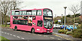
Bus, Mossley West station, Newtownabbey (December 2016)
Metro Wright-bodied Volvo (2350 SEZ 2350) awaiting departure from Mossley West station with the 11.17 1D to Donegall Place (41 minutes).
Image: © Albert Bridge
Taken: 31 Dec 2016
0.20 miles
9
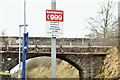
"999" sign, Mossley West station, Newtownabbey (December 2016)
Now standard at NIR stations this one is on the platform at Mossley West. A short history of the number is available here https://en.wikipedia.org/wiki/999_(emergency_telephone_number).
Image: © Albert Bridge
Taken: 31 Dec 2016
0.20 miles
10

Former footbridge, Mossley West station, Newtownabbey
A closed, and fenced-off footbridge, at the Antrim end of Mossley West station (background in Image). See also Image
Image: © Albert Bridge
Taken: 9 Jun 2012
0.21 miles