IMAGES TAKEN NEAR TO
Hillview Park, NEWTOWNABBEY, BT36 5HW
Introduction
This page details the photographs taken nearby to Hillview Park, BT36 5HW by members of the Geograph project.
The Geograph project started in 2005 with the aim of publishing, organising and preserving representative images for every square kilometre of Great Britain, Ireland and the Isle of Man.

There are currently over 7.5m images from over14,400 individuals and you can help contribute to the project by visiting https://www.geograph.org.uk
Image Map
Images are licensed for reuse under creativecommons.org/licenses/by-sa/2.0
Notes
- Clicking on the map will re-center to the selected point.
- The higher the marker number, the further away the image location is from the centre of the postcode.
Image Listing (15 Images Found)
Images are licensed for reuse under creativecommons.org/licenses/by-sa/2.0
Image
Details
Distance
1
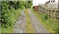
Lane, Glengormley, Newtownabbey
An unsurfaced lane, off the Ballyclare Road, between Queen’s Park (hidden left) and Sally Gardens.
Image: © Albert Bridge
Taken: 25 Jun 2012
0.10 miles
2
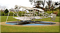
"Mayfly" aircraft sculpture, Glengormley
A sculpture, by Skelton Rainey, of the biplane “Mayfly” http://en.wikipedia.org/wiki/Bland_Mayfly , in Glengormley Park, Ballyclare Road, commemorating Lilian Bland http://www.newulsterbiography.co.uk/index.php/home/viewPerson/117, the first woman to design, build and fly her own aeroplane. See also Image
Image: © Albert Bridge
Taken: 24 Mar 2014
0.12 miles
3
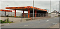
Former petrol station, Glengormley, Newtownabbey
A former Maxol (latterly a car wash), on the Ballyclare Road, opposite Queen’s Park.
Image: © Albert Bridge
Taken: 25 Jun 2012
0.12 miles
4
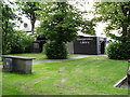
Glengormley Library
Glengormley Library - formerly under the North Eastern Education & Library Board (NEELB)- and now part of Libraries NI. On Carnmoney Road.
Image: © Dean Molyneaux
Taken: 10 Jul 2009
0.13 miles
5
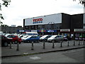
Shops - Glengormley
Tesco (formerly Stewarts), Winemark and various other retail outlets on the Carnmoney Road in Glengormley. The grey building to the far left is Glengormley Health Centre.
Image: © Dean Molyneaux
Taken: 10 Jul 2009
0.13 miles
6
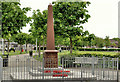
Glengormley war memorial (1)
Glengormley war memorial on the Ballyclare Road. Similar to the one at Whiteabbey Image Image shows the inscription.
Image: © Albert Bridge
Taken: 29 May 2012
0.14 miles
7
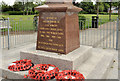
Glengormley war memorial (2)
See Image The inscription.
Image: © Albert Bridge
Taken: 29 May 2012
0.14 miles
8
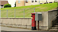
Drop box and pillar box, Glengormley, Newtownabbey
Drop box and EIIR pillar box (BT36 594), on the Ballyclare Road, at Queen’s Park (background).
Image: © Albert Bridge
Taken: 25 Jun 2012
0.16 miles
9
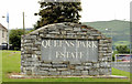
Queen's Park sign, Glengormley, Newtownabbey
The “welcome” sign, at the entrance to the Queen’s Park estate on the Ballyclare Road. For something similar see Image
Image: © Albert Bridge
Taken: 25 Jun 2012
0.16 miles
10
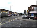
Ballyclare Road, Glengormley
At the junction with Portland Avenue.
Image: © Dean Molyneaux
Taken: 20 Aug 2009
0.18 miles