IMAGES TAKEN NEAR TO
Ballyclare Road, NEWTOWNABBEY, BT36 4SP
Introduction
This page details the photographs taken nearby to Ballyclare Road, BT36 4SP by members of the Geograph project.
The Geograph project started in 2005 with the aim of publishing, organising and preserving representative images for every square kilometre of Great Britain, Ireland and the Isle of Man.

There are currently over 7.5m images from over14,400 individuals and you can help contribute to the project by visiting https://www.geograph.org.uk
Image Map
Images are licensed for reuse under creativecommons.org/licenses/by-sa/2.0
Notes
- Clicking on the map will re-center to the selected point.
- The higher the marker number, the further away the image location is from the centre of the postcode.
Image Listing (10 Images Found)
Images are licensed for reuse under creativecommons.org/licenses/by-sa/2.0
Image
Details
Distance
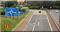
1

The A8(M), Newtownabbey (1)
The inward lanes (right) near the start of the climb from Corr’s Corner roundabout Image (background) seen from the flyover on the Ballycraigy Road Image Last seen in May 2007 Image
Image: © Albert Bridge
Taken: 25 Jun 2012
0.13 miles
2
The A8(M), Newtownabbey (2)
The outward lanes (left), as they descend towards Corr’s Corner roundabout Image (background), seen from the flyover on the Ballycraigy Road Image
Image: © Albert Bridge
Taken: 25 Jun 2012
0.15 miles
3
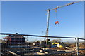
Under construction
Another new house going up on the Ballycraigy Road near Glengormley. No sign of a housing shortage here. The builders are making sure that their cement mixer doesn't get nicked!
Image: © Robert Ashby
Taken: 23 Nov 2014
0.16 miles
4
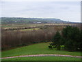
Countryside near Corr's Corner
View of countryside near Corr's Corner. In the distance is Mossley Mill and beyond is Knockagh monument.
Image: © Gary Thompson
Taken: 10 Jan 2009
0.17 miles
5
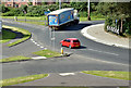
Corr's Corner roundabout, Newtownabbey - June 2017(2)
See Image The south-eastern side of Corr’s Corner roundabout from here Image The Ballyclare Road (to Glengormley) is at upper left. The roads (bottom left) serve the Global Point Business Park.
Image: © Albert Bridge
Taken: 17 Jun 2017
0.17 miles
6

National Cycle Network sign, Corr's Corner, Newtownabbey (June 2017)
National Cycle Network signpost to the east of Corr’s Corner roundabout Image Route 93 runs via here Image to Mossley Mill Image and Image
Image: © Albert Bridge
Taken: 17 Jun 2017
0.19 miles
7
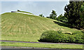
Mound, Corr's Corner, Newtownabbey (June 2017)
An artificial mound, with seat and spiral path, overlooking Corr’s Corner roundabout Image and Image
Image: © Albert Bridge
Taken: 17 Jun 2017
0.19 miles
8
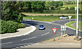
Corr's Corner roundabout, Newtownabbey - June 2017(1)
See Image (September 2006). The northern side of Corr’s Corner roundabout from here Image The Ballyclare Road is towards the top right. The Larne dual carriageway is at bottom right.
Image: © Albert Bridge
Taken: 17 Jun 2017
0.20 miles
9
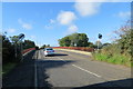
Ballycraigy Road
A car crosses the bridge which carries the Ballycraigy Road over the A8(M) between Sandyknowes Roundabout and Corr's Corner.
Image: © Robert Ashby
Taken: 17 Oct 2013
0.22 miles
10
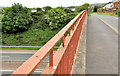
Flyover near Glengormley, Newtownabbey
The flyover (looking in the direction of the Ballyclare Road) carrying the Ballycraigy Road Image across the A8(M).
Image: © Albert Bridge
Taken: 25 Jun 2012
0.23 miles