IMAGES TAKEN NEAR TO
Hightown Avenue, NEWTOWNABBEY, BT36 4RT
Introduction
This page details the photographs taken nearby to Hightown Avenue, BT36 4RT by members of the Geograph project.
The Geograph project started in 2005 with the aim of publishing, organising and preserving representative images for every square kilometre of Great Britain, Ireland and the Isle of Man.

There are currently over 7.5m images from over14,400 individuals and you can help contribute to the project by visiting https://www.geograph.org.uk
Image Map
Images are licensed for reuse under creativecommons.org/licenses/by-sa/2.0
Notes
- Clicking on the map will re-center to the selected point.
- The higher the marker number, the further away the image location is from the centre of the postcode.
Image Listing (4 Images Found)
Images are licensed for reuse under creativecommons.org/licenses/by-sa/2.0
Image
Details
Distance
1
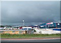
Henderson Food Services Depot at Newtownabbey
Henderson own the Spar and Vivo franchises for Northern Ireland. The depot stands next to the M2.
Image: © Eric Jones
Taken: 9 Aug 2011
0.12 miles
2
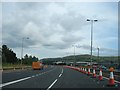
Slip Road at Junction 4 of the M2
The Fire Engine is not as it appears. You can rent it out for parties.
Image: © Ian Paterson
Taken: 24 Jul 2007
0.19 miles
3
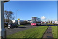
Old Coach Road
The Old Coach Road (B92) at Mallusk, a busy area full of industrial estates and car showrooms to the south of the M2 in Newtownabbey.
Image: © Robert Ashby
Taken: 5 Nov 2014
0.23 miles
4
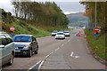
Sandyknowes roundabout near Belfast (3)
See Image The north-bound off-slip from the M2. This is controlled by lights.
Image: © Albert Bridge
Taken: 27 Oct 2007
0.25 miles