IMAGES TAKEN NEAR TO
Park Manor, NEWTOWNABBEY, BT36 4QH
Introduction
This page details the photographs taken nearby to Park Manor, BT36 4QH by members of the Geograph project.
The Geograph project started in 2005 with the aim of publishing, organising and preserving representative images for every square kilometre of Great Britain, Ireland and the Isle of Man.

There are currently over 7.5m images from over14,400 individuals and you can help contribute to the project by visiting https://www.geograph.org.uk
Image Map
Images are licensed for reuse under creativecommons.org/licenses/by-sa/2.0
Notes
- Clicking on the map will re-center to the selected point.
- The higher the marker number, the further away the image location is from the centre of the postcode.
Image Listing (7 Images Found)
Images are licensed for reuse under creativecommons.org/licenses/by-sa/2.0
Image
Details
Distance
1
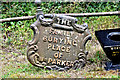
William Parker family grave marker, Mallusk cemetery (August 2017)
A cast iron grave marker, with the inscription “The family burying place of Wm Parker”, at Mallusk Cemetery. No foundry name shown but similar to other Millfield Foundry examples nearby.
Image: © Albert Bridge
Taken: 12 Aug 2017
0.03 miles
2
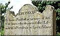
Janet Parkhill headstone, Mallusk cemetery (August 2017)
One of the older and best-preserved headstones at Mallusk cemetery. The inscription reads “Erected by James Parkhill in memory of his wife Janet, who departed this Life, on the 15th. of October 1833. Aged 62 years.”
Image: © Albert Bridge
Taken: 12 Aug 2017
0.03 miles
3
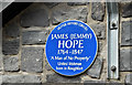
"Jemmy" Hope plaque, Mallusk (August 2017)
A blue plaque, at Mallusk Cemetery, commemorating James (Jemmy) Hope – a locally-born United Irishman. See http://www.hidden-gems.eu/antrim%20-%20hope.pdf and https://en.wikipedia.org/wiki/James_Hope_(Ireland).
Image: © Albert Bridge
Taken: 12 Aug 2017
0.04 miles
4
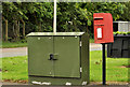
Letter box, Mallusk, Newtownabbey
Post-mounted EIIR letter box (BT36 633) at the Mallusk Road end of Parkmount Road.
Image: © Albert Bridge
Taken: 25 Jun 2012
0.11 miles
5
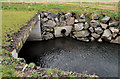
The Black Water, Mallusk, Newtownabbey
The Black Water as it flows from a culvert under the Park Road, Mallusk. It rises a short distance to the south east and flows into the Ballymartin Water to the north west. The latter joins the Sixmilewater north of Templepatrick.
Image: © Albert Bridge
Taken: 25 Jan 2012
0.17 miles
6
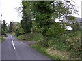
Sealstown Road
Heading east towards Glengormley
Image: © Kenneth Allen
Taken: 14 Oct 2009
0.24 miles
7
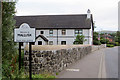
Welcome to Mallusk
Houses along Park Road.
Image: © Robert Ashby
Taken: 6 Sep 2015
0.25 miles