IMAGES TAKEN NEAR TO
Aughanduff Road, NEWRY, BT35 9YD
Introduction
This page details the photographs taken nearby to Aughanduff Road, BT35 9YD by members of the Geograph project.
The Geograph project started in 2005 with the aim of publishing, organising and preserving representative images for every square kilometre of Great Britain, Ireland and the Isle of Man.

There are currently over 7.5m images from over14,400 individuals and you can help contribute to the project by visiting https://www.geograph.org.uk
Image Map
Images are licensed for reuse under creativecommons.org/licenses/by-sa/2.0
Notes
- Clicking on the map will re-center to the selected point.
- The higher the marker number, the further away the image location is from the centre of the postcode.
Image Listing (9 Images Found)
Images are licensed for reuse under creativecommons.org/licenses/by-sa/2.0
Image
Details
Distance
1
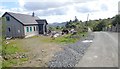
New bungalow under construction on the Aughanduff Road
Image: © Eric Jones
Taken: 12 Sep 2018
0.00 miles
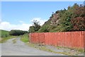
2
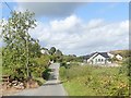
Ribbon development along Aughanduff Road
Image: © Eric Jones
Taken: 12 Sep 2018
0.00 miles
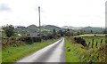
3
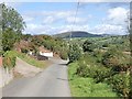
View North along the middle section of Aughanduff Road
Image: © Eric Jones
Taken: 12 Sep 2018
0.01 miles
5
Entrance drive leading from the Aughanduff Road
This leads to a new house some 400m to the North.
Image: © Eric Jones
Taken: 12 Sep 2018
0.13 miles
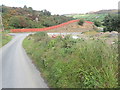
6
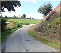
Bends and potholes on the Aughanduff Road
Image: © Eric Jones
Taken: 12 Sep 2018
0.13 miles
7
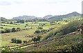
View South along the Ballinn River Valley
The image taken from the Aughanduff Road shows the flood plain of the Ballinn River. The hills in the background are in the south-western quadrant of the Ring of Gullion.
Image: © Eric Jones
Taken: 12 Sep 2018
0.18 miles
8
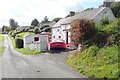
Refurbished traditional homestead on Aughanduff Road
Image: © Eric Jones
Taken: 12 Sep 2018
0.20 miles
9
The western half of the Ring of Gullion viewed from the Tate Road
Image: © Eric Jones
Taken: 12 Sep 2018
0.22 miles