IMAGES TAKEN NEAR TO
Back Road, NEWRY, BT35 9XS
Introduction
This page details the photographs taken nearby to Back Road, BT35 9XS by members of the Geograph project.
The Geograph project started in 2005 with the aim of publishing, organising and preserving representative images for every square kilometre of Great Britain, Ireland and the Isle of Man.

There are currently over 7.5m images from over14,400 individuals and you can help contribute to the project by visiting https://www.geograph.org.uk
Image Map
Images are licensed for reuse under creativecommons.org/licenses/by-sa/2.0
Notes
- Clicking on the map will re-center to the selected point.
- The higher the marker number, the further away the image location is from the centre of the postcode.
Image Listing (8 Images Found)
Images are licensed for reuse under creativecommons.org/licenses/by-sa/2.0
Image
Details
Distance
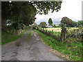
1
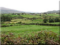
Settlement along Back Road, Mullaghbawn, viewed from Ballinasack Road
Settlement avoid the marshy valley floor and opt for the drier interfluve land.
Image: © Eric Jones
Taken: 2 Sep 2014
0.07 miles
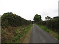
4
Valley floor bogland between Ballinasack Road and the Back Road, Mullaghbawn
Image: © Eric Jones
Taken: 2 Sep 2014
0.16 miles
5
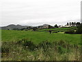
View across farmland towards the Back Road, Mullaghbawn
The image was taken from Cranny Road. The hills of the Ring of Gullion form the background.
Image: © Eric Jones
Taken: 2 Sep 2014
0.19 miles
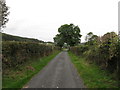
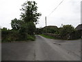
7
Access lane leading to a farmhouse on the east side of Back Road, Mullaghbawn
Slieve Gullion can be seen in the background.
Image: © Eric Jones
Taken: 2 Sep 2014
0.21 miles
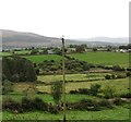
8
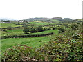
The valley of a tributary of the Forkhill River viewed from Ballinasack Road
The houses on the interfluve are on the Back Road. The hills in the background, part of the Ring of Gullion, include Mullaghbawn Mountain and Croslieve.
Image: © Eric Jones
Taken: 2 Sep 2014
0.23 miles