IMAGES TAKEN NEAR TO
Forkhill Business Park, NEWRY, BT35 9WE
Introduction
This page details the photographs taken nearby to Forkhill Business Park, BT35 9WE by members of the Geograph project.
The Geograph project started in 2005 with the aim of publishing, organising and preserving representative images for every square kilometre of Great Britain, Ireland and the Isle of Man.

There are currently over 7.5m images from over14,400 individuals and you can help contribute to the project by visiting https://www.geograph.org.uk
Image Map
Images are licensed for reuse under creativecommons.org/licenses/by-sa/2.0
Notes
- Clicking on the map will re-center to the selected point.
- The higher the marker number, the further away the image location is from the centre of the postcode.
Image Listing (108 Images Found)
Images are licensed for reuse under creativecommons.org/licenses/by-sa/2.0
Image
Details
Distance
1
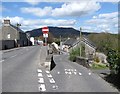
Exit from the one-way road linking Carrickstricken Road and Forkhill's Main Street
Image: © Eric Jones
Taken: 30 Apr 2013
0.01 miles
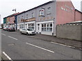
2
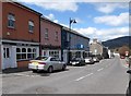
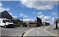
Shops on Main Street, Forkhill
Forkhill has a number of shops and businesses one would not normally find in a rural village.
Image: © Eric Jones
Taken: 30 Apr 2013
0.01 miles
3
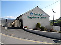
Forkhill Business Centre, Forkhill
This is situated on Main Street and is backed by School Road. The Centre is built on the site of the H Division's Forkhill Royal Ulster Constabulary (RUC) barracks. The barracks were destroyed in a rocket attack in 1982 after which the police were accommodated in the Forkhill Army Base across the road.
https://www.bbc.co.uk/news/uk-northern-ireland-46187620
Image: © Eric Jones
Taken: 17 May 2013
0.01 miles
4
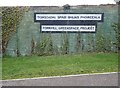
Bilingual signs at the entrance to the Forkhill Greenspace Project
The project is the formation of a woodland park on the site of the former Forkhill Joint Army/RUC Base. Images of the base can be viewed on the following link.
https://www.pprune.org/military-aviation/399005-shfni-stories-16.html
Image: © Eric Jones
Taken: 4 Jan 2019
0.01 miles
5
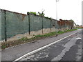
Remains of the outer defensive wall of the former Joint Army and Police Base at Forkhill
Since 2005 Forkhill has been policed from Crossmaglen. Image of the Forkhill base (and of the Crossmaglen (XMG) base) can be seen on the following links.
http://www.pprune.org/military-aircrew/399005-shfni-stories-14.html
http://www.royalulsterconstabulary.org/lastyear.htm
The site is now being developed as a park.
https://www.bbc.co.uk/news/uk-northern-ireland-46187620
Image: © Eric Jones
Taken: 21 Aug 2013
0.02 miles
6
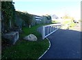
Entrance to the Forkhill Peace Park
This new tree park occupies the site of the former FKL Army/RUC Base in School Lane, Forkhill. Over a thousand trees have been planted.
https://www.bbc.co.uk/news/uk-northern-ireland-39230636
Image: © Eric Jones
Taken: 17 Oct 2018
0.02 miles
7
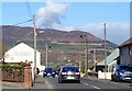
Main Street, Forkhill
Slieve Gullion forms the dramatic background.
Image: © Eric Jones
Taken: 17 Oct 2018
0.02 miles
8
Forkhill Business Centre, Forkhill
These buildings occupy the site of an RUC station which was blown up during The Troubles.
Image: © Eric Jones
Taken: 4 Jan 2019
0.02 miles
9
School Road, Forkhill
The fencing is all that remains of the former FKL Joint Army/Police base. During "The Troubles" the base - built around an existing police station -dominated the landscape. The base was supplied by helicopters from the Bessbrook then the busiest heliport in Europe. The site is now being redeveloped for housing. The base can be seen in Ron Murray's Geograph of 2006,
Image]
http://www.pprune.org/military-aircrew/399005-shfni-stories-16.html
http://www.place.uk.net/downloads/ForkhillBarracksSite_ProgressReport.pdf
Image: © Eric Jones
Taken: 30 Apr 2013
0.02 miles
10
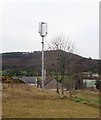
Mobile telephone mast behind the Forkhill Telephone Exchange
The mountain in the background is Tievecrom. The image was taken from inside the now abandoned FKL Joint Army/RUC base.
Image: © Eric Jones
Taken: 4 Jan 2019
0.03 miles