IMAGES TAKEN NEAR TO
Crooked Road, NEWRY, BT35 9UZ
Introduction
This page details the photographs taken nearby to Crooked Road, BT35 9UZ by members of the Geograph project.
The Geograph project started in 2005 with the aim of publishing, organising and preserving representative images for every square kilometre of Great Britain, Ireland and the Isle of Man.

There are currently over 7.5m images from over14,400 individuals and you can help contribute to the project by visiting https://www.geograph.org.uk
Image Map
Images are licensed for reuse under creativecommons.org/licenses/by-sa/2.0
Notes
- Clicking on the map will re-center to the selected point.
- The higher the marker number, the further away the image location is from the centre of the postcode.
Image Listing (21 Images Found)
Images are licensed for reuse under creativecommons.org/licenses/by-sa/2.0
Image
Details
Distance
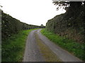
1
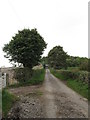
View northwestwards along a straight section of the Crooked Road
Image: © Eric Jones
Taken: 12 Sep 2014
0.04 miles
3
Crooked Road east of the junction with Duburren Road
Image: © Eric Jones
Taken: 12 Sep 2014
0.06 miles
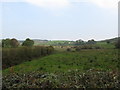
4
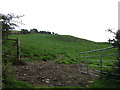
Reclaimed grazing land on the top of the Ring of Gullion scarp
The image was taken from the Crooked Road.
Image: © Eric Jones
Taken: 12 Sep 2014
0.09 miles
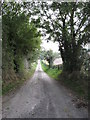
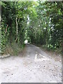
5
Crooked Road starting its descent down to Lislea
Image: © Eric Jones
Taken: 12 Sep 2014
0.10 miles
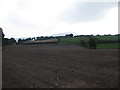
6
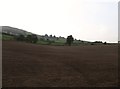
Ploughed field on the south side of the Crooked Road
Image: © Eric Jones
Taken: 12 Sep 2014
0.11 miles
8
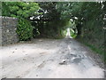
Crooked Road approaching the concealed exit of Duburren Road
Image: © Eric Jones
Taken: 12 Sep 2014
0.14 miles
9
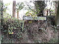
A crooked name plate on Crooked Road, Lislea
Image: © Eric Jones
Taken: 12 Sep 2014
0.14 miles
10
Wetland bounded by Crooked Road and Duburren Road
Image: © Eric Jones
Taken: 12 Sep 2014
0.14 miles