IMAGES TAKEN NEAR TO
Milltown Road, NEWRY, BT35 9UF
Introduction
This page details the photographs taken nearby to Milltown Road, BT35 9UF by members of the Geograph project.
The Geograph project started in 2005 with the aim of publishing, organising and preserving representative images for every square kilometre of Great Britain, Ireland and the Isle of Man.

There are currently over 7.5m images from over14,400 individuals and you can help contribute to the project by visiting https://www.geograph.org.uk
Image Map
Images are licensed for reuse under creativecommons.org/licenses/by-sa/2.0
Notes
- Clicking on the map will re-center to the selected point.
- The higher the marker number, the further away the image location is from the centre of the postcode.
Image Listing (9 Images Found)
Images are licensed for reuse under creativecommons.org/licenses/by-sa/2.0
Image
Details
Distance
2
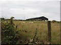
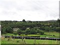
Modern steel farm shed above Milltown Road
The farming in the area around Lislea, which is hilly, is predomiantly pastoral. Both sheep and store cattle are grazed on the hill land.
Image: © Eric Jones
Taken: 27 Aug 2014
0.15 miles
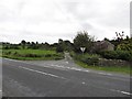
5
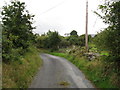
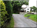
Milltown Road
This is the section of Milltown Road that links with the village of Lislea.
Image: © Eric Jones
Taken: 27 Aug 2014
0.18 miles
7
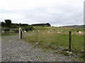
Disused quarry on the east side of the B30 at Lislea
The image was taken from Hall Road.
Image: © Eric Jones
Taken: 27 Aug 2014
0.22 miles
8
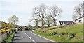
Traditional cottage above the Milltown Road
The cloud capped Slieve Gullion forms the background.
Image: © Eric Jones
Taken: 27 Aug 2014
0.23 miles
9
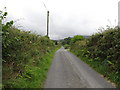
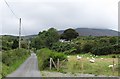
View across the B30 towards the western end of Milltown Road
Image: © Eric Jones
Taken: 27 Aug 2014
0.24 miles