IMAGES TAKEN NEAR TO
Glebe Park, NEWRY, BT35 9TH
Introduction
This page details the photographs taken nearby to Glebe Park, BT35 9TH by members of the Geograph project.
The Geograph project started in 2005 with the aim of publishing, organising and preserving representative images for every square kilometre of Great Britain, Ireland and the Isle of Man.

There are currently over 7.5m images from over14,400 individuals and you can help contribute to the project by visiting https://www.geograph.org.uk
Image Map
Images are licensed for reuse under creativecommons.org/licenses/by-sa/2.0
Notes
- Clicking on the map will re-center to the selected point.
- The higher the marker number, the further away the image location is from the centre of the postcode.
Image Listing (77 Images Found)
Images are licensed for reuse under creativecommons.org/licenses/by-sa/2.0
Image
Details
Distance
1

Anti-Brexit Posters at the Hunger Strikers' Memorial at Mullaghbawn
Image: © Eric Jones
Taken: 14 May 2019
0.04 miles
2
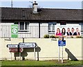
European Election Posters at Mullaghbawn
Mullaghbawn is a strongly Nationalist community.
Image: © Eric Jones
Taken: 14 May 2019
0.04 miles
3
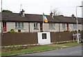
Hunger Strikers' Memorial at Mullaghbawn
This memorial to the ten republican prisoners who died as a result of a Hunger Strike in 1981 is located on the main street of Mullaghbawn.
http://cain.ulst.ac.uk/events/hstrike/dead.htm
Image: © Eric Jones
Taken: 2 Sep 2014
0.04 miles
4
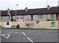
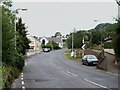
The junction of Maphoner Road and Church Road in the centre of Mullaghbawn
Image: © Eric Jones
Taken: 4 Jan 2019
0.05 miles
5

Sinn F?in European Election Poster at Mullaghbawn
Image: © Eric Jones
Taken: 14 May 2019
0.05 miles
7
The Valley, Mullaghbawn, at the junction with Maphoner Road
St Mary's Chapel can be seen in the background.
Image: © Eric Jones
Taken: 2 Sep 2014
0.05 miles
8
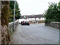
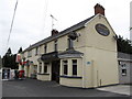
View south westwards across Mullaghbawn Bridge
The bridge spans the Forkhill River.
Image: © Eric Jones
Taken: 2 Sep 2014
0.06 miles
9
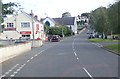
Church Street, Mullaghbawn
This image was taken from the junction with Maphoner Road. The Chapel is that of St Mary's, Mullaghbawn. Church Street proceeds Southwards towards Forkhill.
Image: © Eric Jones
Taken: 24 Sep 2018
0.06 miles
10
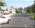
View Southwards along Church Street, Mullaghbawn
This image was taken from the junction with Maphoner Road towards the Church of St Mary's, Mullaghbawn. Church Street proceeds in the direction of Forkhill.
Image: © Eric Jones
Taken: 28 Aug 2019
0.06 miles