IMAGES TAKEN NEAR TO
Copperfields, NEWRY, BT35 9PU
Introduction
This page details the photographs taken nearby to Copperfields, BT35 9PU by members of the Geograph project.
The Geograph project started in 2005 with the aim of publishing, organising and preserving representative images for every square kilometre of Great Britain, Ireland and the Isle of Man.

There are currently over 7.5m images from over14,400 individuals and you can help contribute to the project by visiting https://www.geograph.org.uk
Image Map
Images are licensed for reuse under creativecommons.org/licenses/by-sa/2.0
Notes
- Clicking on the map will re-center to the selected point.
- The higher the marker number, the further away the image location is from the centre of the postcode.
Image Listing (6 Images Found)
Images are licensed for reuse under creativecommons.org/licenses/by-sa/2.0
Image
Details
Distance
1
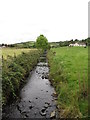
Ummeracam River above Ummeracam Bridge
The river is joined by another tributary just before it flows under the bridge which carries Callaghans Road.
Image: © Eric Jones
Taken: 2 Sep 2014
0.10 miles
2
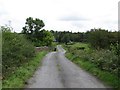
Approaching Ummeracam Bridge on Callaghans Road
This is in the upper reaches of the Cully Water river.
Image: © Eric Jones
Taken: 2 Sep 2014
0.11 miles
3
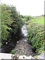
The Ummeracam River below the Ummeracam Bridge on Callaghans Road
Image: © Eric Jones
Taken: 2 Sep 2014
0.12 miles
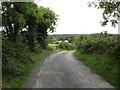
4
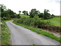
Callaghans Road ascending from Ummeracam Bridge towards the Drumalt Road
The bridge spans the Ummeracam River, a tributary of the Cully Water.
Image: © Eric Jones
Taken: 2 Sep 2014
0.16 miles
5
Callaghans Road descending into the Ummeracam valley
Image: © Eric Jones
Taken: 2 Sep 2014
0.21 miles
6
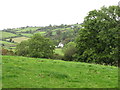
The incised valley of a tributary of the Ummeracam
This image was taken from Drumalt Road.
Image: © Eric Jones
Taken: 2 Sep 2014
0.23 miles