IMAGES TAKEN NEAR TO
Cully Road, NEWRY, BT35 9LP
Introduction
This page details the photographs taken nearby to Cully Road, BT35 9LP by members of the Geograph project.
The Geograph project started in 2005 with the aim of publishing, organising and preserving representative images for every square kilometre of Great Britain, Ireland and the Isle of Man.

There are currently over 7.5m images from over14,400 individuals and you can help contribute to the project by visiting https://www.geograph.org.uk
Image Map
Images are licensed for reuse under creativecommons.org/licenses/by-sa/2.0
Notes
- Clicking on the map will re-center to the selected point.
- The higher the marker number, the further away the image location is from the centre of the postcode.
Image Listing (4 Images Found)
Images are licensed for reuse under creativecommons.org/licenses/by-sa/2.0
Image
Details
Distance
1
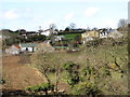
Settlement on the Cully Road
This image was taken from the junction of Carrive Road and Cashel Road. Photographer and subject are separated by the incised valley of the Cully Water.
Image: © Eric Jones
Taken: 30 Apr 2013
0.19 miles
2
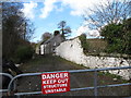
Derelict farmhouse alongside the Carrive Road
The structures here are in a dangerous condition.
Image: © Eric Jones
Taken: 30 Apr 2013
0.23 miles
4
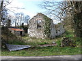
Ruined farm buildings alongside Cully Water
Image: © Eric Jones
Taken: 30 Apr 2013
0.25 miles