IMAGES TAKEN NEAR TO
Carrig Place, NEWRY, BT35 9LB
Introduction
This page details the photographs taken nearby to Carrig Place, BT35 9LB by members of the Geograph project.
The Geograph project started in 2005 with the aim of publishing, organising and preserving representative images for every square kilometre of Great Britain, Ireland and the Isle of Man.

There are currently over 7.5m images from over14,400 individuals and you can help contribute to the project by visiting https://www.geograph.org.uk
Image Map
Images are licensed for reuse under creativecommons.org/licenses/by-sa/2.0
Notes
- Clicking on the map will re-center to the selected point.
- The higher the marker number, the further away the image location is from the centre of the postcode.
Image Listing (9 Images Found)
Images are licensed for reuse under creativecommons.org/licenses/by-sa/2.0
Image
Details
Distance
1
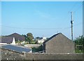
Traditional farm buildings east of Creggan
Image: © Eric Jones
Taken: 11 Sep 2014
0.01 miles
2
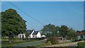
Houses at the southern end of Drummill Road, Creggan
Image: © Eric Jones
Taken: 11 Sep 2014
0.04 miles
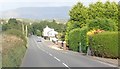
3
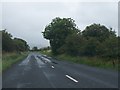
The B30 (Newry Road) approaching the junction with Lurgan Road
Image: © Eric Jones
Taken: 21 Aug 2013
0.11 miles
4
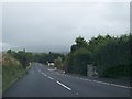
View east along the B30 (Newry Road) between Creggan and Silverbridge
Image: © Eric Jones
Taken: 21 Aug 2013
0.12 miles
5
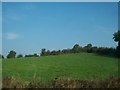
Drumlin pasture land on the eastern outskirts of Creggan
Image: © Eric Jones
Taken: 11 Sep 2014
0.13 miles
6
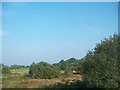
Wetland seen from the B30 east of Creggan
Image: © Eric Jones
Taken: 11 Sep 2014
0.17 miles
7
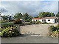
Bungalow at Carrig Place on the Drumill Road
The image was taken from the B30.
Image: © Eric Jones
Taken: 6 Sep 2019
0.21 miles
8
Houses on the B30 (Newry Road) west of Silverbridge
Image: © Eric Jones
Taken: 28 Aug 2019
0.24 miles
9

Detached house on the B30 West of Silverbridge
Image: © Eric Jones
Taken: 28 Aug 2019
0.24 miles