IMAGES TAKEN NEAR TO
Alley Road, NEWRY, BT35 9HY
Introduction
This page details the photographs taken nearby to Alley Road, BT35 9HY by members of the Geograph project.
The Geograph project started in 2005 with the aim of publishing, organising and preserving representative images for every square kilometre of Great Britain, Ireland and the Isle of Man.

There are currently over 7.5m images from over14,400 individuals and you can help contribute to the project by visiting https://www.geograph.org.uk
Image Map
Images are licensed for reuse under creativecommons.org/licenses/by-sa/2.0
Notes
- Clicking on the map will re-center to the selected point.
- The higher the marker number, the further away the image location is from the centre of the postcode.
Image Listing (16 Images Found)
Images are licensed for reuse under creativecommons.org/licenses/by-sa/2.0
Image
Details
Distance
1
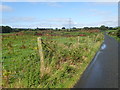
Rough grazing West of the middle section of Alley Road
The pylons of the North-South Interconnector can be seen advancing north-westwards in the direction of Tandragee.
http://www.soni.ltd.uk/media/New-SONI-transmission-map.JPG
Image: © Eric Jones
Taken: 6 Sep 2019
0.04 miles
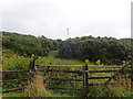
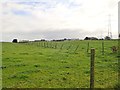
2
Whin covered quarry waste on the East side of Alley Road
The North-South interconnector passes by in the middle ground.
Image: © Eric Jones
Taken: 6 Sep 2019
0.05 miles
3
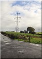
North-South Interconnector crossing the entrance to a farm on the Alley Road
Image: © Eric Jones
Taken: 6 Sep 2019
0.10 miles
4
Whin covered drumlin land east of Alley Road
Image: © Eric Jones
Taken: 6 Sep 2019
0.11 miles
5
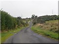
View North-eastwards along the ascending Alley Road
Alley Road links Dundalk Road and Monog Road.
Image: © Eric Jones
Taken: 6 Sep 2019
0.14 miles
6
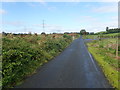
The North-South Interconnector power lines crossing Alley Road
Image: © Eric Jones
Taken: 6 Sep 2019
0.16 miles
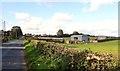
7
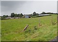
Farm house and buildings on the east side of Alley Road
The North-South Interconnector approaches on the right.
Image: © Eric Jones
Taken: 6 Sep 2019
0.20 miles
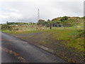
8
Farm outbuildings on the north side of the Dundalk Road
This section of road is in the Townland of Craignoran.
Image: © Eric Jones
Taken: 24 Sep 2018
0.22 miles
9
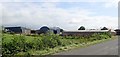
Farm buildings on the Dundalk Road
The image was taken from the Alley Road.
Image: © Eric Jones
Taken: 6 Sep 2019
0.22 miles
10
Farm buildings on the Dundalk Road
These are located just west of the Moybane Cross Roads. The North-South Interconnector can be seen in the background.
Image: © Eric Jones
Taken: 6 Sep 2019
0.22 miles