IMAGES TAKEN NEAR TO
Mullanstown, NEWRY, BT35 9EX
Introduction
This page details the photographs taken nearby to Mullanstown, BT35 9EX by members of the Geograph project.
The Geograph project started in 2005 with the aim of publishing, organising and preserving representative images for every square kilometre of Great Britain, Ireland and the Isle of Man.

There are currently over 7.5m images from over14,400 individuals and you can help contribute to the project by visiting https://www.geograph.org.uk
Image Map
Images are licensed for reuse under creativecommons.org/licenses/by-sa/2.0
Notes
- Clicking on the map will re-center to the selected point.
- The higher the marker number, the further away the image location is from the centre of the postcode.
Image Listing (65 Images Found)
Images are licensed for reuse under creativecommons.org/licenses/by-sa/2.0
Image
Details
Distance
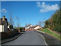
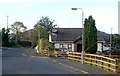
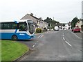
2
Mullanstown Estate viewed from Tullymacreeve Road
Slieve Gullion forms the background.
Image: © Eric Jones
Taken: 30 Apr 2013
0.03 miles
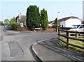
3
Mullanstown, Mullaghbawn
The image was taken from Maphoner Road.
Image: © Eric Jones
Taken: 2 Sep 2014
0.03 miles
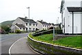
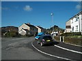
4
Bungalow in Poet's Meadow off Maphoner Road, Mullaghbawn
Poet's Meadow is a new village edge residential estate.
Image: © Eric Jones
Taken: 24 Sep 2018
0.05 miles
5
Houses on the Poet's Meadow Estate, Mullaghbawn
South Armagh was a major centre of Gaelic poetic culture in the 18th C. Places associated with these poets can be visited along the Poet's Trail.
http://www.south-armagh.com/index.cfm/area/activities/page/activityList/activities_key/35
Image: © Eric Jones
Taken: 12 Sep 2014
0.05 miles
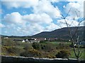
6
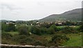
Houses at Maphoner, Mullaghbawn viewed from the Tullymacreeve Road
In the foreground is the parapet of a bridge on Tullymacreeve Road which spans a stream which flows from Mullaghbawn Lough. Slieve Gullion forms the background.
Image: © Eric Jones
Taken: 2 Sep 2014
0.05 miles
7
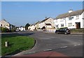
Conway Park Estate, Mullaghbawn
The image was taken from Maphoner Road.
Image: © Eric Jones
Taken: 11 Sep 2014
0.07 miles
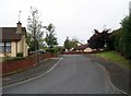
9
Conway Park, Mullaghbane
Mullaghbane (also known as Mullaghbawn) is a village which has considerably expanded during the past two decades with the addition of new housing estates.
Image: © Eric Jones
Taken: 30 Apr 2013
0.07 miles