IMAGES TAKEN NEAR TO
Leeter Road, NEWRY, BT35 9EW
Introduction
This page details the photographs taken nearby to Leeter Road, BT35 9EW by members of the Geograph project.
The Geograph project started in 2005 with the aim of publishing, organising and preserving representative images for every square kilometre of Great Britain, Ireland and the Isle of Man.

There are currently over 7.5m images from over14,400 individuals and you can help contribute to the project by visiting https://www.geograph.org.uk
Image Map
Images are licensed for reuse under creativecommons.org/licenses/by-sa/2.0
Notes
- Clicking on the map will re-center to the selected point.
- The higher the marker number, the further away the image location is from the centre of the postcode.
Image Listing (12 Images Found)
Images are licensed for reuse under creativecommons.org/licenses/by-sa/2.0
Image
Details
Distance
1
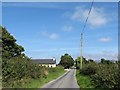
House on Leeter Road, Glasdrumman, Crossmaglen
Image: © Eric Jones
Taken: 10 Sep 2014
0.00 miles
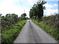
2

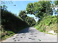
View south-westwards along Leeter Road near Glasdrumman
Image: © Eric Jones
Taken: 10 Sep 2014
0.03 miles
6
View west along Loughaveely Road
This image was taken from its junction with Leeter Road.
Image: © Eric Jones
Taken: 10 Sep 2014
0.15 miles
7
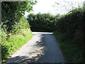
Loughaveely Road approaching its junction with Leeter Road
Image: © Eric Jones
Taken: 10 Sep 2014
0.15 miles
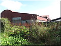
8
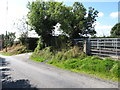
Leeter Road at its junction with the minor Lochaveeley Road
A sheep pen is located near the junction.
Image: © Eric Jones
Taken: 10 Sep 2014
0.16 miles

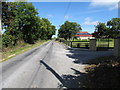
10
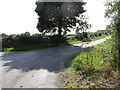
Leeter Road at its junction with Glasdrumman Road
Image: © Eric Jones
Taken: 10 Sep 2014
0.23 miles