IMAGES TAKEN NEAR TO
Larkins Road, NEWRY, BT35 9EQ
Introduction
This page details the photographs taken nearby to Larkins Road, BT35 9EQ by members of the Geograph project.
The Geograph project started in 2005 with the aim of publishing, organising and preserving representative images for every square kilometre of Great Britain, Ireland and the Isle of Man.

There are currently over 7.5m images from over14,400 individuals and you can help contribute to the project by visiting https://www.geograph.org.uk
Image Map
Images are licensed for reuse under creativecommons.org/licenses/by-sa/2.0
Notes
- Clicking on the map will re-center to the selected point.
- The higher the marker number, the further away the image location is from the centre of the postcode.
Image Listing (3 Images Found)
Images are licensed for reuse under creativecommons.org/licenses/by-sa/2.0
Image
Details
Distance
2
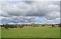
Drumlins skirting the Creggan River flood plain
The image was taken from the Coolderry Road.
Image: © Eric Jones
Taken: 24 Sep 2018
0.14 miles
3
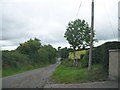
View northwest in the direction of Crossmaglen along Larkin's Road
Image: © Eric Jones
Taken: 21 Aug 2013
0.18 miles