IMAGES TAKEN NEAR TO
Glassdrumman Road, NEWRY, BT35 9EB
Introduction
This page details the photographs taken nearby to Glassdrumman Road, BT35 9EB by members of the Geograph project.
The Geograph project started in 2005 with the aim of publishing, organising and preserving representative images for every square kilometre of Great Britain, Ireland and the Isle of Man.

There are currently over 7.5m images from over14,400 individuals and you can help contribute to the project by visiting https://www.geograph.org.uk
Image Map
Images are licensed for reuse under creativecommons.org/licenses/by-sa/2.0
Notes
- Clicking on the map will re-center to the selected point.
- The higher the marker number, the further away the image location is from the centre of the postcode.
Image Listing (4 Images Found)
Images are licensed for reuse under creativecommons.org/licenses/by-sa/2.0
Image
Details
Distance
1
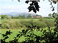
Farmland and red barns on the Armagh/Louth border
Parts of the scenic Ring of Gullion form the background.
Image: © Eric Jones
Taken: 10 Sep 2014
0.15 miles
2
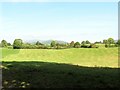
View across farmland in the direction of Forkhill
This image was taken from Mounthill Road.
Image: © Eric Jones
Taken: 10 Sep 2014
0.19 miles
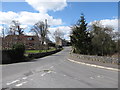
4
Amenity land at Ballsmill
This river side picnic area is located at the centre of the village where Ballsmill Road and Glasdrumman Road merge.
Image: © Eric Jones
Taken: 30 Apr 2013
0.23 miles