IMAGES TAKEN NEAR TO
Kiltybane Road, NEWRY, BT35 9BH
Introduction
This page details the photographs taken nearby to Kiltybane Road, BT35 9BH by members of the Geograph project.
The Geograph project started in 2005 with the aim of publishing, organising and preserving representative images for every square kilometre of Great Britain, Ireland and the Isle of Man.

There are currently over 7.5m images from over14,400 individuals and you can help contribute to the project by visiting https://www.geograph.org.uk
Image Map
Images are licensed for reuse under creativecommons.org/licenses/by-sa/2.0
Notes
- Clicking on the map will re-center to the selected point.
- The higher the marker number, the further away the image location is from the centre of the postcode.
Image Listing (8 Images Found)
Images are licensed for reuse under creativecommons.org/licenses/by-sa/2.0
Image
Details
Distance
1
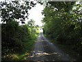
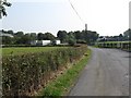
View along the tree-lined Kiltybane Road south of the Anamar Primary School
Image: © Eric Jones
Taken: 11 Sep 2014
0.05 miles
2
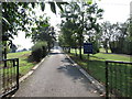
The entrance drive to Anamar Primary School, Annaghmare TD
This pleasantly situated rural primary school was recently threatened with closure. A lively campaign by staff and parents against the Council for Catholic Maintained Schools (CCMS) closure plan saw it successfully shelved.
http://www.crossexaminer.co.uk/archives/1897
Image: © Eric Jones
Taken: 11 Sep 2014
0.10 miles
3
Anamar Primary School, Kiltybane Road, Crossmaglen
This small rural Catholic ethos school a couple of miles north west of Crossmaglen was at one time threatened with closure but a vigorous campaign by staff and parents managed to change the mind of the authorities.
http://www.crossexaminer.co.uk/archives/1897
Image: © Eric Jones
Taken: 11 Sep 2014
0.12 miles
4
Approaching Anamar Primary School on the Kiltybane Road
Image: © Eric Jones
Taken: 11 Sep 2014
0.13 miles
5
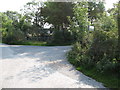
Annaghmare Road at its junction with Kiltybane Road
The sign post directs visitors to Achadh an Marbh (Annagmare) Court Tomb.
Image
Image: © Eric Jones
Taken: 11 Sep 2014
0.16 miles
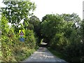
6
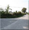
View north along Kiltybane Road from the junction with Annaghmare Road
Image: © Eric Jones
Taken: 11 Sep 2014
0.19 miles
7
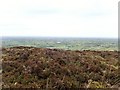
View West from Croslieve Mountain
This view covers the lowlands and lakes of the South Armagh/Co Monaghan Border Area. The largest lake visible in this image is Lake Muckno which is entirely within the Irish Republic.
Image: © Eric Jones
Taken: 14 May 2019
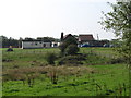
0.21 miles
8
Static caravan storage yard off Kiltybane Road
Image: © Eric Jones
Taken: 11 Sep 2014
0.21 miles