IMAGES TAKEN NEAR TO
Concession Road, NEWRY, BT35 9AR
Introduction
This page details the photographs taken nearby to Concession Road, BT35 9AR by members of the Geograph project.
The Geograph project started in 2005 with the aim of publishing, organising and preserving representative images for every square kilometre of Great Britain, Ireland and the Isle of Man.

There are currently over 7.5m images from over14,400 individuals and you can help contribute to the project by visiting https://www.geograph.org.uk
Image Map
Images are licensed for reuse under creativecommons.org/licenses/by-sa/2.0
Notes
- Clicking on the map will re-center to the selected point.
- The higher the marker number, the further away the image location is from the centre of the postcode.
Image Listing (8 Images Found)
Images are licensed for reuse under creativecommons.org/licenses/by-sa/2.0
Image
Details
Distance
1
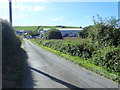
Industrial and business units at the junction of Loughross Road and Concession Road
The image was taken from the Loughross Road.
Image: © Eric Jones
Taken: 18 Sep 2019
0.07 miles
2
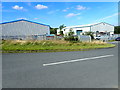
Industrial units near The Loughross Road junction with the A37 (Concession Road)
Image: © Eric Jones
Taken: 18 Sep 2019
0.08 miles
3
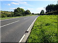
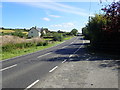
Concession Road east of the Loughross Road junction
Image: © Eric Jones
Taken: 18 Sep 2019
0.08 miles
4
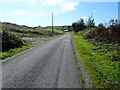
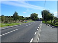
View SSW along Loughross Road
The ridge in the background slopes Southwards to the Fane Valley which marks the border between Northern Ireland and The Republic of Ireland.
Image: © Eric Jones
Taken: 18 Sep 2019
0.17 miles
5
Modern detached house on Concession Road, Cullaville
This is located on the Western approach to the village.
Image: © Eric Jones
Taken: 18 Sep 2019
0.18 miles
7
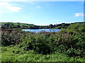
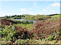
Cornahave Lough from the Loughross Road
Enclosed by drumlins, this is a constituent lake of the Castleblayney Lake District.
Image: © Eric Jones
Taken: 18 Sep 2019
0.23 miles
8
View ESE along the N37 in the direction of Culloville
Image: © Eric Jones
Taken: 18 Sep 2019
0.25 miles