IMAGES TAKEN NEAR TO
Creamery Road, NEWRY, BT35 9AD
Introduction
This page details the photographs taken nearby to Creamery Road, BT35 9AD by members of the Geograph project.
The Geograph project started in 2005 with the aim of publishing, organising and preserving representative images for every square kilometre of Great Britain, Ireland and the Isle of Man.

There are currently over 7.5m images from over14,400 individuals and you can help contribute to the project by visiting https://www.geograph.org.uk
Image Map
Images are licensed for reuse under creativecommons.org/licenses/by-sa/2.0
Notes
- Clicking on the map will re-center to the selected point.
- The higher the marker number, the further away the image location is from the centre of the postcode.
Image Listing (7 Images Found)
Images are licensed for reuse under creativecommons.org/licenses/by-sa/2.0
Image
Details
Distance
1
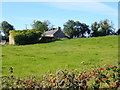
Former small holding on the West side of Creamery Road
Image: © Eric Jones
Taken: 18 Sep 2019
0.02 miles
2
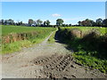
Farm track leading East from Creamery Road
Image: © Eric Jones
Taken: 18 Sep 2019
0.02 miles
3
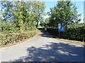
The Creamery Road entrance to the Carran Hill Water Treatment Works, Crossmaglen
Carran Hill Water Treatment Works treats water from Lough Ross
http://www.ceequal.com/case-studies/carran-hill-water-treatment-works/
Image: © Eric Jones
Taken: 18 Sep 2019
0.12 miles
4
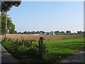
Farmhouse and buildings on the east side of Carran Road, Crossmaglen
Image: © Eric Jones
Taken: 11 Sep 2014
0.18 miles
5
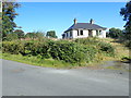
Empty bungalow on the Creamery Road
This property appears to be abandoned.
Image: © Eric Jones
Taken: 18 Sep 2019
0.18 miles
6
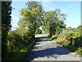
The NW stretch of Creamery Road, Crossmaglen
In the distance Creamery Road joins the B135 (Carran Road) at the staggered Carran Hill Cross Roads.
Image: © Eric Jones
Taken: 18 Sep 2019
0.20 miles
7
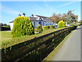
Glencarron Care Home, Creamery Road, Crossmaglen
This is a privately owned Care Home with nursing. It is registered for a maximum of 44 service users.
Image: © Eric Jones
Taken: 18 Sep 2019
0.24 miles