IMAGES TAKEN NEAR TO
Ashwood, BT35 8XU
Introduction
This page details the photographs taken nearby to Ashwood, BT35 8XU by members of the Geograph project.
The Geograph project started in 2005 with the aim of publishing, organising and preserving representative images for every square kilometre of Great Britain, Ireland and the Isle of Man.

There are currently over 7.5m images from over14,400 individuals and you can help contribute to the project by visiting https://www.geograph.org.uk
Image Map
Images are licensed for reuse under creativecommons.org/licenses/by-sa/2.0
Notes
- Clicking on the map will re-center to the selected point.
- The higher the marker number, the further away the image location is from the centre of the postcode.
Image Listing (10 Images Found)
Images are licensed for reuse under creativecommons.org/licenses/by-sa/2.0
Image
Details
Distance
1
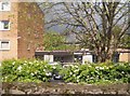
Entrance to the Nurses Home at Daisy Hill Hospital, Newry
Image: © Eric Jones
Taken: 16 May 2012
0.07 miles
2
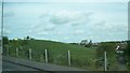
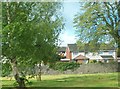
Part of the green belt between inner Newry and the Derrybeg Housing Estate
The church in the background is St Brigid's
Image: © Eric Jones
Taken: 16 May 2014
0.17 miles
3
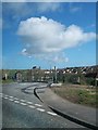
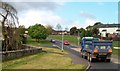
Unnamed road leading to the Housing Executive estate of Derrybeg
Image: © Eric Jones
Taken: 30 Apr 2013
0.17 miles
4
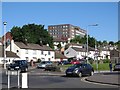
Newry's Daisy Hill Hospital towering above Camlough Road
Image: © Eric Jones
Taken: 7 Jun 2013
0.17 miles
5
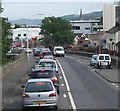
Daisy Hill Hospital, Newry viewed from the junction of Monaghan Street and Monaghan Row
Image: © Eric Jones
Taken: 11 Apr 2018
0.17 miles
6
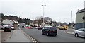
The Camlough Road near Daisy Hill Hospital
The heavy traffic is bound for the city centre.
Image: © Eric Jones
Taken: 19 Jun 2013
0.18 miles
7
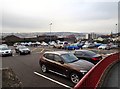
Car Park at the Daisy Hill Hospital, Newry
Image: © Eric Jones
Taken: 11 Apr 2018
0.21 miles
8
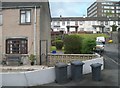
Houses in a cul-de-sac off Camlough Road
The large building in the background is Daisy Hill Hospital.
Image: © Eric Jones
Taken: 15 May 2012
0.22 miles
9
New housing estate in Monaghan Row
This image was taken from Camlough Road. The green area in the foreground is a disused graveyard.
Image: © Eric Jones
Taken: 15 May 2012
0.22 miles
10
Carnagat Road off Camlough Road
This road leads to a large Housing Executive estate.
Image: © Eric Jones
Taken: 15 May 2012
0.22 miles