IMAGES TAKEN NEAR TO
New Line, NEWRY, BT35 8SZ
Introduction
This page details the photographs taken nearby to New Line, BT35 8SZ by members of the Geograph project.
The Geograph project started in 2005 with the aim of publishing, organising and preserving representative images for every square kilometre of Great Britain, Ireland and the Isle of Man.

There are currently over 7.5m images from over14,400 individuals and you can help contribute to the project by visiting https://www.geograph.org.uk
Image Map
Images are licensed for reuse under creativecommons.org/licenses/by-sa/2.0
Notes
- Clicking on the map will re-center to the selected point.
- The higher the marker number, the further away the image location is from the centre of the postcode.
Image Listing (48 Images Found)
Images are licensed for reuse under creativecommons.org/licenses/by-sa/2.0
Image
Details
Distance
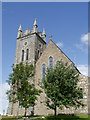
1
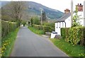
House alongside the New Line Road at Drumintee
The forested south facing slope of Slieve Gullion forms the background.
Image: © Eric Jones
Taken: 16 May 2013
0.01 miles
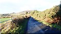
2
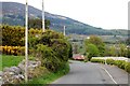
View north along the New Line Road at Drumintee
Slieve Gullion forms the background.
Image: © Eric Jones
Taken: 16 May 2013
0.03 miles
3
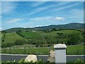
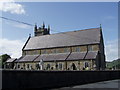
New cemetery at Drumintee
This is located across the road from Drumintee Chapel.
Image: © Eric Jones
Taken: 20 Jun 2012
0.11 miles
7
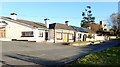
The Three Steps Bar and Lounge, Drumintee /Dromintee
The car park of the Three Steps was where the undercover officer Capt. Robert Nairac CG was kidnapped in 1977 and taken over to the Ravensdale area of the Republic where he was tortured and killed.
http://www.newrymemoirs.com/stories_pages/slievegulltroubles_1.html
Image: © Eric Jones
Taken: 3 Dec 2018
0.15 miles
9
Unnamed road linking Dromintee with the descending forestry drive
Slieve Gullion and its western foothill together with the grassy re-entrant between them are visible from this point. The junction with the forest drive is just beyond the plantation of dark coloured conifers in the background centre.
Image: © Eric Jones
Taken: 3 Dec 2018
0.18 miles
10
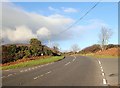
Bend in the B113 at Dromintee/Drumintee
The image was taken from the car park of the Three Steps Lounge and Bar. Slieve Gullion stands in the background on the left.
Image: © Eric Jones
Taken: 3 Dec 2018
0.18 miles