IMAGES TAKEN NEAR TO
Aghadavoyle Road, NEWRY, BT35 8SN
Introduction
This page details the photographs taken nearby to Aghadavoyle Road, BT35 8SN by members of the Geograph project.
The Geograph project started in 2005 with the aim of publishing, organising and preserving representative images for every square kilometre of Great Britain, Ireland and the Isle of Man.

There are currently over 7.5m images from over14,400 individuals and you can help contribute to the project by visiting https://www.geograph.org.uk
Image Map
Images are licensed for reuse under creativecommons.org/licenses/by-sa/2.0
Notes
- Clicking on the map will re-center to the selected point.
- The higher the marker number, the further away the image location is from the centre of the postcode.
Image Listing (17 Images Found)
Images are licensed for reuse under creativecommons.org/licenses/by-sa/2.0
Image
Details
Distance
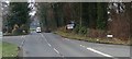
1
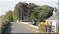
Northern section of Aghadavoyle Road
The camera points North.
Image: © Eric Jones
Taken: 14 May 2019
0.08 miles
2
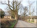
Aghadavoyle Road approaching its junction with Dromintee Road
Image: © Eric Jones
Taken: 14 Feb 2019
0.08 miles
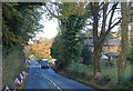
3
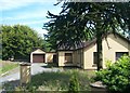
Bungalow south-west of Meigh on the Drumintee Road
Image: © Eric Jones
Taken: 20 Jun 2012
0.08 miles
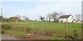
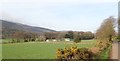
4
Farm buildings between Aghadavoyle Road and Dromintee Road
The forested south-eastern slopes of Slieve Gullion form the background.
Image: © Eric Jones
Taken: 14 Feb 2019
0.09 miles
5
Detached housing near the junction of Aghadavoyle Road and Dromintee Road
The larger of the three is recently built, the site being previously occupied by a derelict farm house and out buildings.
https://www.instantstreetview.com/@54.112962,-6.400339,42.01h,11.79p,1z
Image: © Eric Jones
Taken: 14 Feb 2019
0.09 miles
6
Road works signs on the B113 south-west of Chambres, Kileavy
Image: © Eric Jones
Taken: 29 Oct 2018
0.11 miles
7
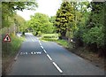
Drumintee Road at its junction with Aghadavoyle Road
Aghadavoyle Road leads to Jonesborough.
Image: © Eric Jones
Taken: 16 May 2013
0.12 miles
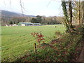
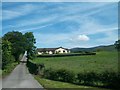
9
Farmland between Aghadavoyle Road and Dromintee Road
Slieve Gullion forms the background.
Image: © Eric Jones
Taken: 14 Feb 2019
0.14 miles
10
Private drive providing access to bungalow near Meigh
Image: © Eric Jones
Taken: 20 Jun 2012
0.16 miles