IMAGES TAKEN NEAR TO
Foughilletra Road, NEWRY, BT35 8SH
Introduction
This page details the photographs taken nearby to Foughilletra Road, BT35 8SH by members of the Geograph project.
The Geograph project started in 2005 with the aim of publishing, organising and preserving representative images for every square kilometre of Great Britain, Ireland and the Isle of Man.

There are currently over 7.5m images from over14,400 individuals and you can help contribute to the project by visiting https://www.geograph.org.uk
Image Map
Images are licensed for reuse under creativecommons.org/licenses/by-sa/2.0
Notes
- Clicking on the map will re-center to the selected point.
- The higher the marker number, the further away the image location is from the centre of the postcode.
Image Listing (8 Images Found)
Images are licensed for reuse under creativecommons.org/licenses/by-sa/2.0
Image
Details
Distance
1

Powerlines running either side of the railway line north of Adavoyle Station
Image: © Eric Jones
Taken: 14 Feb 2019
0.17 miles
2
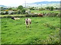
Cattle seen from the Foughilletra Road
The village of Meigh Image can be seen to the left in the middle distance; the peak on the horizon is Camlough Mountain Image
Image: © Oliver Dixon
Taken: 13 May 2007
0.20 miles
3
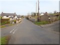
The Station Road junction on the Foughilletra Road
Station Road descends downhill to Adavoyle Railway Bridge. Foughilletra Road continues northwards to the junction with Railway Road at Meigh.
Image: © Eric Jones
Taken: 14 Feb 2019
0.21 miles
4
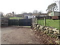
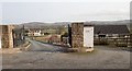
Traditional cottage on the west side of Lower Foughill Road
The cottage has been adapted to farm storage use.
Image: © Eric Jones
Taken: 14 Feb 2019
0.22 miles
5

The Dublin to Belfast Railway North of Adavoyle Bridge
The bridge in the background carries a private track linking farmland with Foughilletra Road.
Image: © Eric Jones
Taken: 14 Feb 2019
0.22 miles
6
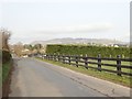
The northern end of Lower Foughill Road
The hills in the background are Camlough Mountain and Ballymacdermot Mountain, both parts of the Ring of Gullion.
Image: © Eric Jones
Taken: 14 Feb 2019
0.24 miles
7

The wooded railway cutting north of Adavoyle Station
The image was taken from the junction of Station Road and Foughilletra Road. Slieve Gullion forms the background.
Image: © Eric Jones
Taken: 14 Feb 2019
0.25 miles
8
Recently built houses along Lower Foughill Road
The mountains in the background form the eastern sector of the Ring of Gullion.
Image: © Eric Jones
Taken: 14 Feb 2019
0.25 miles