IMAGES TAKEN NEAR TO
Kellys Road, NEWRY, BT35 8RY
Introduction
This page details the photographs taken nearby to Kellys Road, BT35 8RY by members of the Geograph project.
The Geograph project started in 2005 with the aim of publishing, organising and preserving representative images for every square kilometre of Great Britain, Ireland and the Isle of Man.

There are currently over 7.5m images from over14,400 individuals and you can help contribute to the project by visiting https://www.geograph.org.uk
Image Map
Images are licensed for reuse under creativecommons.org/licenses/by-sa/2.0
Notes
- Clicking on the map will re-center to the selected point.
- The higher the marker number, the further away the image location is from the centre of the postcode.
Image Listing (10 Images Found)
Images are licensed for reuse under creativecommons.org/licenses/by-sa/2.0
Image
Details
Distance
1
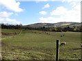
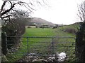
Sheep grazings on the border
The border runs along the hedge on the far right in the image. The northern flank of the Cooley uplands forms the background.
Image: © Eric Jones
Taken: 26 Feb 2015
0.06 miles
2
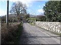
View westwards along Kellys Road
Here Kellys Road is within a stone's throw of the Border which follows the course of a nearby stream.
Image: © Eric Jones
Taken: 26 Feb 2015
0.08 miles
4
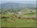
View across Killeen in the direction of the village of Meigh
Meigh is located on the Forkhill Road at the foot of Slieve Gullion. The green sheds are those of the distribution firm Kingstorage whose depot is on the Border.
Image: © Eric Jones
Taken: 7 Jun 2018
0.11 miles
5
Field track leading in the direction of the Border
Image: © Eric Jones
Taken: 26 Feb 2015
0.12 miles
6

Undulating glacial deposits on the north side of Kellys Road
This land is used for pastoral agriculture.
Image: © Eric Jones
Taken: 26 Feb 2015
0.13 miles
7
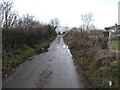
Puddles on Kellys Road
The image was taken westwards in the direction of the Dublin Road.
Image: © Eric Jones
Taken: 26 Feb 2015
0.18 miles
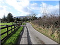
8
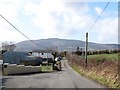
Farmhouse and outbuildings on Kellys Road
Slieve Gullion forms the background.
Image: © Eric Jones
Taken: 26 Feb 2015
0.22 miles
9
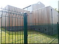
New extension to Killean Primary School, Killean
This is the product of a recent £1.25m building project providing a new multi-purpose hall and a new front entrance to the school.
Image: © Eric Jones
Taken: 19 May 2018
0.24 miles
10
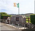
Republican memorial on Kelly's Road, Killeen
The memorial on the left commemorates Máire Drumm, Vice President of Sinn Fein and a native of Killeen, who was murdered in the Mater Hospital, Belfast by Loyalist paramilitary gunmen in October 1976. Next to it is a memorial to two young local IRA men who were blown up by their own bomb at this spot near the junction with the Dublin Road in December 1975. A total of 21 persons - civilian and military, ranging in age from 6 to 72 years - were murdered in the Killeen district during the Troubles and more than 200 in the wider South Armagh area.
Image: © Eric Jones
Taken: 19 May 2018
0.25 miles