IMAGES TAKEN NEAR TO
Low Road, NEWRY, BT35 8RH
Introduction
This page details the photographs taken nearby to Low Road, BT35 8RH by members of the Geograph project.
The Geograph project started in 2005 with the aim of publishing, organising and preserving representative images for every square kilometre of Great Britain, Ireland and the Isle of Man.

There are currently over 7.5m images from over14,400 individuals and you can help contribute to the project by visiting https://www.geograph.org.uk
Image Map
Images are licensed for reuse under creativecommons.org/licenses/by-sa/2.0
Notes
- Clicking on the map will re-center to the selected point.
- The higher the marker number, the further away the image location is from the centre of the postcode.
Image Listing (11 Images Found)
Images are licensed for reuse under creativecommons.org/licenses/by-sa/2.0
Image
Details
Distance
1
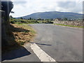
Unnamed junction on the Low Road
Here the Low Road is emerging from a railway underpass.
Image: © Eric Jones
Taken: 2 Aug 2019
0.06 miles
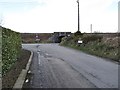
2
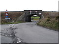
Railway bridge at the junction of Lower Newtown Road and Low Road
This bridge has a height restriction of 11 feet (3.4m).
Image: © Eric Jones
Taken: 26 Feb 2015
0.06 miles
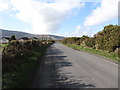
3
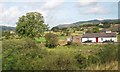
The South Armagh countryside east of Meigh
The gap between Slieve Gullion and Camlough Mountain can be seen in the background.
Image: © Eric Jones
Taken: 22 Aug 2009
0.07 miles
4
Railway bridge and junction near Meigh
The bridge carries the main Belfast to Dublin railway line.
Image: © Oliver Dixon
Taken: 13 May 2007
0.07 miles
5
The junction of Lower Newtown Road and Low Road near the Low Road railway bridge
Image: © Eric Jones
Taken: 26 Feb 2015
0.08 miles
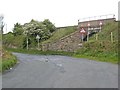
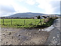
7
Private road leading from Low Road to houses on the north side of the railway line
The road makes use of a former farm land access under pass below the Belfast to Dublin railway line.
Image: © Eric Jones
Taken: 26 Feb 2015
0.17 miles
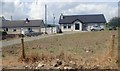
8
Rural industry near Meigh
Probably a bedding factory, but there is no sign outside. The dark heap against the building on the left side of the photograph is a pile of interior springs from mattresses.
Image: © Oliver Dixon
Taken: 13 May 2007
0.19 miles
9
View WNW along Lower Newtown Road
Slieve Gullion forms the background.
Image: © Eric Jones
Taken: 26 Feb 2015
0.19 miles
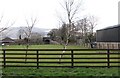
10
Bungalows on Lower Newtown Road
The buildings in the middle distance are the workshops of SVG Marble and Granites on Low Road. The forested Slieve Gullion forms the background. The track in the foreground is a farm access track.
Image: © Eric Jones
Taken: 26 Feb 2015
0.22 miles