IMAGES TAKEN NEAR TO
Brogies Road, NEWRY, BT35 8NW
Introduction
This page details the photographs taken nearby to Brogies Road, BT35 8NW by members of the Geograph project.
The Geograph project started in 2005 with the aim of publishing, organising and preserving representative images for every square kilometre of Great Britain, Ireland and the Isle of Man.

There are currently over 7.5m images from over14,400 individuals and you can help contribute to the project by visiting https://www.geograph.org.uk
Image Map
Images are licensed for reuse under creativecommons.org/licenses/by-sa/2.0
Notes
- Clicking on the map will re-center to the selected point.
- The higher the marker number, the further away the image location is from the centre of the postcode.
Image Listing (19 Images Found)
Images are licensed for reuse under creativecommons.org/licenses/by-sa/2.0
Image
Details
Distance
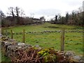
1
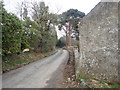
Brogies Road on the outskirts of Newry
The image was taken from the point where the Ring of Gullion Way green lane meets the metalled road. The building and walling on the right are those of a dilapidated farm cottage. The site is currently being redeveloped.
Image: © Eric Jones
Taken: 13 Mar 2018
0.05 miles
2
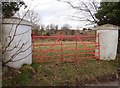
Traditional Ulster pillared field gate on Brogies Road
Image: © Eric Jones
Taken: 13 Mar 2018
0.06 miles
3
Countryside east of the A1 near Cloghoge
Image: © Eric Jones
Taken: 25 May 2010
0.10 miles

5
Undulating landscape between the Belfast-Dublin Railway line and Flagstaff Road
Image: © Eric Jones
Taken: 13 Mar 2018
0.15 miles
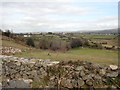
6
Rough pasture and woodland on the north-east side of the railway at Cloghoge
Image: © Eric Jones
Taken: 13 Mar 2018
0.16 miles
7
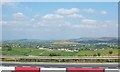
Cloghoge village from the A1
Cloghoge has in recent years become a suburb of Newry.
Image: © Eric Jones
Taken: 25 May 2010
0.17 miles
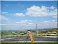
8
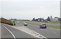
The A2/B113 slip road on the A1 on the outskirts of Newry
The building on the right is the Church of the Sacred Heart, Cloghue.
Image: © Eric Jones
Taken: 9 Apr 2018
0.18 miles
9

View WNW along the northern section of Fathom Road, Newry
In the background beyond the A1 viaduct are Cloghogue Mountain, Ballymacdermot Mountain and, with the telecommunications masts on its summit ridge, Camlough Mountain. All are parts of the Gullion Ring Dyke.
Image: © Eric Jones
Taken: 13 Mar 2018
0.19 miles
10
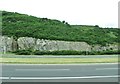
A1 cutting
The A1 runs along the slopes of a ridge immediately west of the city of Newry.
Image: © Eric Jones
Taken: 5 Jul 2016
0.19 miles