IMAGES TAKEN NEAR TO
Carrickateel Court, NEWRY, BT35 8NU
Introduction
This page details the photographs taken nearby to Carrickateel Court, BT35 8NU by members of the Geograph project.
The Geograph project started in 2005 with the aim of publishing, organising and preserving representative images for every square kilometre of Great Britain, Ireland and the Isle of Man.

There are currently over 7.5m images from over14,400 individuals and you can help contribute to the project by visiting https://www.geograph.org.uk
Image Map
Images are licensed for reuse under creativecommons.org/licenses/by-sa/2.0
Notes
- Clicking on the map will re-center to the selected point.
- The higher the marker number, the further away the image location is from the centre of the postcode.
Image Listing (64 Images Found)
Images are licensed for reuse under creativecommons.org/licenses/by-sa/2.0
Image
Details
Distance
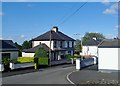
1
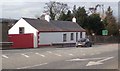
Traditional cottage on Dublin Road, Newry
This is located some 2 miles from the city centre.
Image: © Eric Jones
Taken: 13 Mar 2018
0.05 miles
2
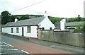
Traditional cottage on the Dublin Road, Newry
Image: © Eric Jones
Taken: 5 Jul 2016
0.05 miles
4

A Political Graffiti on behalf of Sinn F?in
This is painted on the wall of a derelict property at the top of Dublin Road, Newry.
Image: © Eric Jones
Taken: 13 Mar 2018
0.06 miles
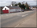
6
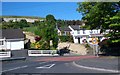
The entrance to Chancellor's Road from the Dublin Road
Image: © Eric Jones
Taken: 28 May 2010
0.06 miles
7
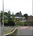
Lisdrum Park road at its junction with Dublin Road
Image: © Eric Jones
Taken: 11 Aug 2016
0.08 miles
8
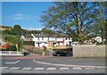
The southern end of Chancellors Road, Newry
Image: © Eric Jones
Taken: 16 May 2013
0.08 miles
9
The entrance into Carrive Drive from Patrician Park, Newry
Image: © Eric Jones
Taken: 21 Jun 2018
0.08 miles