IMAGES TAKEN NEAR TO
Flagstaff Road, NEWRY, BT35 8NS
Introduction
This page details the photographs taken nearby to Flagstaff Road, BT35 8NS by members of the Geograph project.
The Geograph project started in 2005 with the aim of publishing, organising and preserving representative images for every square kilometre of Great Britain, Ireland and the Isle of Man.

There are currently over 7.5m images from over14,400 individuals and you can help contribute to the project by visiting https://www.geograph.org.uk
Image Map
Images are licensed for reuse under creativecommons.org/licenses/by-sa/2.0
Notes
- Clicking on the map will re-center to the selected point.
- The higher the marker number, the further away the image location is from the centre of the postcode.
Image Listing (2 Images Found)
Images are licensed for reuse under creativecommons.org/licenses/by-sa/2.0
Image
Details
Distance
1
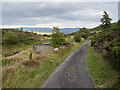
The Windy Road, Fathom
The Windy Road at Fathom Mountain - a very narrow rural road just south of the main A1 between Dundalk and Newry.
Image: © Rossographer
Taken: 5 Aug 2022
0.17 miles
2
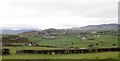
The Eastern section of the Ring of Gullion
These volcanic hills extend in the middle ground southwards and then westwards through Cloughoge Mountain, Fathom Mountain and Flagstaff Mountain to the Cooley Mountains on the border between Armagh and Louth, In the background are the Mourne Mountains of County Down and Slieve Foye, the highest peak on the Cooley Peninsula. The image was taken from the slopes of Ballymacdermot Mountain. The village in the middle ground is Cloughoge.
Image: © Eric Jones
Taken: 21 Mar 2019
0.20 miles