IMAGES TAKEN NEAR TO
Newtown Road, NEWRY, BT35 8NN
Introduction
This page details the photographs taken nearby to Newtown Road, BT35 8NN by members of the Geograph project.
The Geograph project started in 2005 with the aim of publishing, organising and preserving representative images for every square kilometre of Great Britain, Ireland and the Isle of Man.

There are currently over 7.5m images from over14,400 individuals and you can help contribute to the project by visiting https://www.geograph.org.uk
Image Map
Images are licensed for reuse under creativecommons.org/licenses/by-sa/2.0
Notes
- Clicking on the map will re-center to the selected point.
- The higher the marker number, the further away the image location is from the centre of the postcode.
Image Listing (10 Images Found)
Images are licensed for reuse under creativecommons.org/licenses/by-sa/2.0
Image
Details
Distance
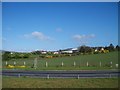
1
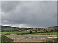
Transport Depot on the Newtown Road, Newtown Cloghoge
Image: © Eric Jones
Taken: 9 Sep 2010
0.02 miles
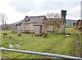
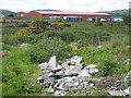
3
Roofless homestead south of the village of Cloughoge
This is located on the West side of the Newtown Road,
Image: © Eric Jones
Taken: 6 Feb 2019
0.08 miles
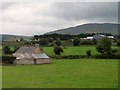
4
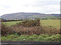
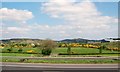
Farmland West of the Newtown Road
The image is taken across the Plain of Meigh. Slieve Gullion forms the background.
Image: © Eric Jones
Taken: 6 Feb 2019
0.11 miles
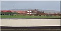
6
Transport depot at Newtown Bridge
Just north of the Border in Northern Ireland.
Image: © Oliver Dixon
Taken: 13 May 2007
0.17 miles
7
Red sheds at Rosie's Closet off the Newtown Road
Image: © Eric Jones
Taken: 6 Feb 2019
0.18 miles
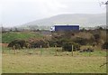
8
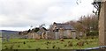
Disused farmhouse north of Killeen Bridge
Image: © Eric Jones
Taken: 17 Jul 2010
0.23 miles
9
Farmland north of the railway at Newtowncloghoge
Image: © Eric Jones
Taken: 25 May 2010
0.23 miles
10
HGV travelling North along the A1 South of Cloughoge
Image: © Eric Jones
Taken: 6 Feb 2019
0.24 miles