IMAGES TAKEN NEAR TO
Chancellors Road, NEWRY, BT35 8NG
Introduction
This page details the photographs taken nearby to Chancellors Road, BT35 8NG by members of the Geograph project.
The Geograph project started in 2005 with the aim of publishing, organising and preserving representative images for every square kilometre of Great Britain, Ireland and the Isle of Man.

There are currently over 7.5m images from over14,400 individuals and you can help contribute to the project by visiting https://www.geograph.org.uk
Image Map
Images are licensed for reuse under creativecommons.org/licenses/by-sa/2.0
Notes
- Clicking on the map will re-center to the selected point.
- The higher the marker number, the further away the image location is from the centre of the postcode.
Image Listing (9 Images Found)
Images are licensed for reuse under creativecommons.org/licenses/by-sa/2.0
Image
Details
Distance
1
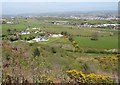
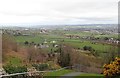
The A1 corridor from the Bernish View Point
The A1 and the Belfast to Dublin railway line run side by side on the western shoulder of the Newry Trench. The city itself grew along the banks of the Newry River and Canal.
Image: © Eric Jones
Taken: 19 Apr 2014
0.12 miles
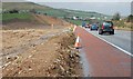
2
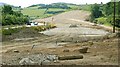
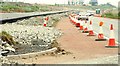
The new Newry bypass (17)
See Image The view south from the Bernish Road with the present (single carriageway) bypass on the left and the new line of the northbound carriageway occupying most of the rest of the photo. Continue to Image
Image: © Albert Bridge
Taken: 27 Jul 2008
0.17 miles
3
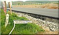
The new Newry bypass (48)
See Image The old road sign. Part of the Bernish Road is now under the new northbound carriageway. Continue to Image
Image: © Albert Bridge
Taken: 14 May 2009
0.17 miles
4
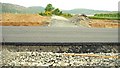
The new Newry bypass (47)
See Image The Bernish Road, looking across the new northbound carriageway. There will no access to or from the road to the new bypass. Continue to Image
Image: © Albert Bridge
Taken: 14 May 2009
0.18 miles
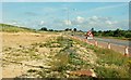
5
Pasture land between Bernish Viewpoint and the A11
The city of Newry lies beyond.
Image: © Eric Jones
Taken: 21 Mar 2019
0.21 miles
6
The new Newry bypass (18)
See Image The view north from the Bernish Road with the line of the Belfast-bound carriageway on the left and the present (single carriageway) bypass on the right. Continue to Image
Image: © Albert Bridge
Taken: 27 Jul 2008
0.21 miles
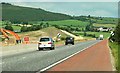
7
The new Newry bypass (14)
See Image Most of the road will follow a new line but this southern section (left) will run alongside and dual the existing single-carriageway bypass. When completed the road will be a high quality dual carriageway (ie a motorway in all but name). Continue to Image
Image: © Albert Bridge
Taken: 8 Mar 2008
0.22 miles
8
The new Newry bypass (16)
See Image Later photographs in this series (taken today) show that a substantial amount of work has taken place in the construction of the bypass. To the layman this section, approaching the Cloghoge roundabout, is where progress is least noticeable. Image shows the road just under five months ago. Continue to Image
Image: © Albert Bridge
Taken: 27 Jul 2008
0.22 miles
9
The new Newry bypass (46)
See Image What will be the northbound carriageway, at the Bernish Road, has now received a surface. It will become a temporary two-way road pending conversion of the existing bypass (right) to the southbound carriageway. Image shows approximately the same view in July 2008. Continue to Image
Image: © Albert Bridge
Taken: 14 May 2009
0.24 miles