IMAGES TAKEN NEAR TO
Dublin Road, NEWRY, BT35 8NE
Introduction
This page details the photographs taken nearby to Dublin Road, BT35 8NE by members of the Geograph project.
The Geograph project started in 2005 with the aim of publishing, organising and preserving representative images for every square kilometre of Great Britain, Ireland and the Isle of Man.

There are currently over 7.5m images from over14,400 individuals and you can help contribute to the project by visiting https://www.geograph.org.uk
Image Map
Images are licensed for reuse under creativecommons.org/licenses/by-sa/2.0
Notes
- Clicking on the map will re-center to the selected point.
- The higher the marker number, the further away the image location is from the centre of the postcode.
Image Listing (41 Images Found)
Images are licensed for reuse under creativecommons.org/licenses/by-sa/2.0
Image
Details
Distance
1
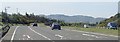
The south-bound A1 approaching the Dublin Road (B113) slip road
Image: © Eric Jones
Taken: 7 Jun 2018
0.03 miles
2
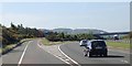
The B113 slip road leading off the A1 dual carriageway south of Cloghoge
The overhead bridge on the right carries the north-bound slip road of the B113.
Image: © Eric Jones
Taken: 7 Jun 2018
0.04 miles
4
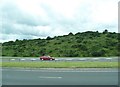
The Dublin-Belfast Railway Line running parallel with Barracric Road
Ahead is a green lane lining Barracric Road and the north-eastern section of Brogies Road. The Ring of Gullion Path follows the green lane.
Image: © Eric Jones
Taken: 13 Mar 2018
0.07 miles
5
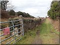
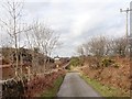
Green lane running North from a bend in Barracric Road
The southern half of the green lane runs parallel with the railway line. The locked gate on the right is a private NIR access to the railway track.
Image: © Eric Jones
Taken: 13 Mar 2018
0.08 miles
6
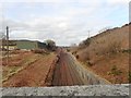
View North in the Newry direction from Barracric Road bridge
This is the Dublin to Belfast railway, and the only surviving cross border line on the whole island of Ireland.
Image: © Eric Jones
Taken: 13 Mar 2018
0.09 miles
7
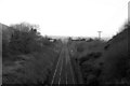
No Trains at Cloghogue
The Belfast to Dublin mainline at Cloghogue. To the right of the railway line is Father Murphy's Chapel, crossing the railway line is a privatly owned access bridge, just pass this point, the railway line curves to the left towards Newry.
Image: © Wilson Adams
Taken: 8 Dec 2006
0.10 miles
8
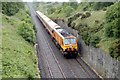
225 at Cloghogue
225 climbing the bank passing Cloghogue
Image: © Wilson Adams
Taken: 24 Jun 2006
0.10 miles
9
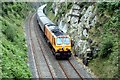
225 at Cloghogue
225 exiting the cutting at Cloghogue
Image: © Wilson Adams
Taken: 13 Jul 2006
0.10 miles
10
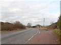
The Barracric Road turnoff on Brogies Road
The steel shed at the bend had not been built when Google Street View passed by in 2011.
https://www.instantstreetview.com/@54.13964,-6.340439,346.07h,3.45p,1z
Image: © Eric Jones
Taken: 13 Mar 2018
0.11 miles