IMAGES TAKEN NEAR TO
Ballintemple Road, NEWRY, BT35 8LH
Introduction
This page details the photographs taken nearby to Ballintemple Road, BT35 8LH by members of the Geograph project.
The Geograph project started in 2005 with the aim of publishing, organising and preserving representative images for every square kilometre of Great Britain, Ireland and the Isle of Man.

There are currently over 7.5m images from over14,400 individuals and you can help contribute to the project by visiting https://www.geograph.org.uk
Image Map
Images are licensed for reuse under creativecommons.org/licenses/by-sa/2.0
Notes
- Clicking on the map will re-center to the selected point.
- The higher the marker number, the further away the image location is from the centre of the postcode.
Image Listing (26 Images Found)
Images are licensed for reuse under creativecommons.org/licenses/by-sa/2.0
Image
Details
Distance
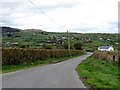
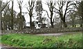
1
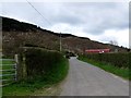
Unnamed road leading north from Killevy Churches to Ballintemple Wood
Image: © Eric Jones
Taken: 11 Apr 2014
0.05 miles
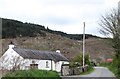
3
Traditional cottage north of Killevy Churches
Image: © Eric Jones
Taken: 11 Apr 2014
0.12 miles
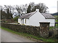
4
Paddy's Cottage
This cottage, on the lower slopes of Slieve Gullion bordering Ballytemple Wood, has been converted to self-catering accommodation and is known as 'Paddy's Cottage'.
Image: © Rossographer
Taken: 22 Sep 2007
0.15 miles
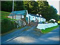
5
Bends at the top of Church Road
This point provides a good view of the upper Flurry valley.
Image: © Eric Jones
Taken: 11 Apr 2014
0.15 miles
6
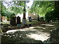
Graves at Killeavy Old Churches
Destroyed during the Reformation these medieval convent churches have remained in a ruined state. As was the tradition in Ireland, Catholics still used the graveyards of the ruined churches to bury their dead.
Image: © Eric Jones
Taken: 21 Jun 2018
0.15 miles
7
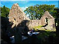
Killevy Old Church
Killevy Old Churches:
Located on the eastern slopes of Slieve Gullion, Killevy is the reputed site of an important Early Christian Convent founded by St Moninna (also known as Darerca or Bline) in the early 6th century. Although there are no remains of the early wooden church buildings, there are two stone churches at the site. The earlier West Church has an imposing 10th or 11th Century doorway and a slightly later round headed east window. While the East Church is medieval, with a 15th Century east window complete with weathered carved heads.
Information from http://www.newryandmourne.gov.uk/tourism/attractions/archaeology.asp#f
Image: © Rossographer
Taken: 22 Sep 2007
0.15 miles
8
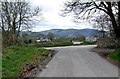
The junction of Church Road and Ballintemple Road at Killevy Churches
Image: © Eric Jones
Taken: 11 Apr 2014
0.16 miles
10
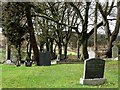
Family graves in the Catholic section of Killevy Churchyard
Image: © Eric Jones
Taken: 11 Apr 2014
0.16 miles