IMAGES TAKEN NEAR TO
Foughilletra Road, NEWRY, BT35 8JE
Introduction
This page details the photographs taken nearby to Foughilletra Road, BT35 8JE by members of the Geograph project.
The Geograph project started in 2005 with the aim of publishing, organising and preserving representative images for every square kilometre of Great Britain, Ireland and the Isle of Man.

There are currently over 7.5m images from over14,400 individuals and you can help contribute to the project by visiting https://www.geograph.org.uk
Image Map
Images are licensed for reuse under creativecommons.org/licenses/by-sa/2.0
Notes
- Clicking on the map will re-center to the selected point.
- The higher the marker number, the further away the image location is from the centre of the postcode.
Image Listing (4 Images Found)
Images are licensed for reuse under creativecommons.org/licenses/by-sa/2.0
Image
Details
Distance
1
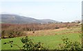
Wooded wetland alongside the Belfast to Dublin railway line
The background is provided by Slieve Gullion.
Image: © Eric Jones
Taken: 14 Feb 2019
0.08 miles
2
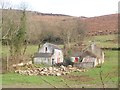
Derelict farmhouse and outbuildings on the western flank of Faughill Mountain
The image was taken from the Foughilletra Road.
Image: © Eric Jones
Taken: 14 Feb 2019
0.09 miles
3
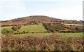
Intake land on the western slopes of Faughill Mountain
Image: © Eric Jones
Taken: 14 Feb 2019
0.17 miles
4

Final bend in the descending Molly Road
Beyond this acute bend, Molly Road joins the Foughilletra Road. Slieve Gullion forms the background.
Image: © Eric Jones
Taken: 14 Feb 2019
0.24 miles