IMAGES TAKEN NEAR TO
Kilnasaggart Road, NEWRY, BT35 8HZ
Introduction
This page details the photographs taken nearby to Kilnasaggart Road, BT35 8HZ by members of the Geograph project.
The Geograph project started in 2005 with the aim of publishing, organising and preserving representative images for every square kilometre of Great Britain, Ireland and the Isle of Man.

There are currently over 7.5m images from over14,400 individuals and you can help contribute to the project by visiting https://www.geograph.org.uk
Image Map
Images are licensed for reuse under creativecommons.org/licenses/by-sa/2.0
Notes
- Clicking on the map will re-center to the selected point.
- The higher the marker number, the further away the image location is from the centre of the postcode.
Image Listing (14 Images Found)
Images are licensed for reuse under creativecommons.org/licenses/by-sa/2.0
Image
Details
Distance
1
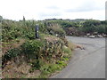
Ring of Gullion Path waymark at the junction of Kilnasaggart Road and Morgans Lane
Image: © Eric Jones
Taken: 9 Aug 2018
0.02 miles
2
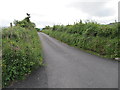
Morgan's Lane
This lane links Kilnasaggart Road and Edenappa Road.
Image: © Eric Jones
Taken: 20 Jun 2012
0.04 miles
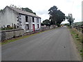
3
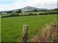
Houses on Morgans Lane, Jonesborough
The image was taken from the Edenappa Road. The whale back mountain in the background is Slieve Gullion.
Image: © Eric Jones
Taken: 9 Aug 2018
0.05 miles
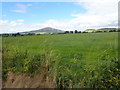
4
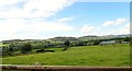
Grazing land west of the Edenappa Road
The hills of the south western section of the Ring of Gullion forms the background.
Image: © Eric Jones
Taken: 9 Aug 2018
0.08 miles
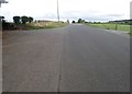
5

View West along Morgans Lane
This lane links Edenappa Road and Kilnasaggart Road.
Image: © Eric Jones
Taken: 9 Aug 2018
0.09 miles
6
Grass crop on the north side of Morgans Lane
The hills in the background are Slieve Gullion and Foughill Mountain.
Image: © Eric Jones
Taken: 9 Aug 2018
0.10 miles
7
The Edenappa Road/Morgans Lane cross roads
The camera points northwards.
Image: © Eric Jones
Taken: 9 Aug 2018
0.14 miles
9
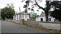
View north past a derelict farmhouse and cottage on the Edenappa Road
Comparison with 2011 Google Street View image shows that the bigger house has since been reroofed.
https://www.instantstreetview.com/@54.078999,-6.372969,45.09h,10.24p,1z
Image: © Eric Jones
Taken: 9 Aug 2018
0.16 miles
10
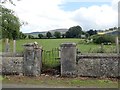
Gateway with a crooked gate on Edenappa Road
The RTE mast on Clermont Carn can be seen in the background.
Image: © Eric Jones
Taken: 9 Aug 2018
0.16 miles