IMAGES TAKEN NEAR TO
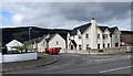
Rath Gullion, NEWRY, BT35 8GN
Introduction
This page details the photographs taken nearby to Rath Gullion, BT35 8GN by members of the Geograph project.
The Geograph project started in 2005 with the aim of publishing, organising and preserving representative images for every square kilometre of Great Britain, Ireland and the Isle of Man.

There are currently over 7.5m images from over14,400 individuals and you can help contribute to the project by visiting https://www.geograph.org.uk
Image Map
Images are licensed for reuse under creativecommons.org/licenses/by-sa/2.0
Notes
- Clicking on the map will re-center to the selected point.
- The higher the marker number, the further away the image location is from the centre of the postcode.
Image Listing (52 Images Found)
Images are licensed for reuse under creativecommons.org/licenses/by-sa/2.0
Image
Details
Distance
1
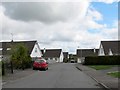
The Rathgullion Estate, Meigh, viewed from Chapel Road
Image: © Eric Jones
Taken: 11 Apr 2014
0.04 miles
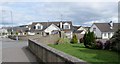
2
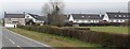
New houses on the eastern outskirts of Meigh
The image was taken from the B113.
Image: © Eric Jones
Taken: 9 Apr 2018
0.05 miles
3
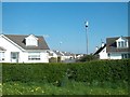
Newly built houses on the Rathgullion Estate, Meigh
Image: © Eric Jones
Taken: 16 May 2013
0.06 miles
4
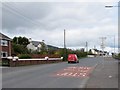
The lower end of Chapel Road at Meigh
This road has its northern end at Camlough village. It is the main north-south communications artery in the upper Flurry valley.
Image: © Eric Jones
Taken: 11 Apr 2014
0.08 miles
5
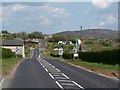
Leaving the 30mph zone in the Newry direction on the B113 at Meigh
Image: © Eric Jones
Taken: 16 May 2013
0.08 miles
6
The northern section of the Rathgullion Estate, Meigh
St Joseph's Chapel can be seen in the background (left).
Image: © Eric Jones
Taken: 11 Apr 2014
0.08 miles
7
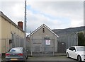
Meigh's Telephone Exchange
Like all telephone exchanges in the 028 region it is well protected by security fences and razor wire. It used to take the name Killeavy before it changed to 028 30 numbers.
Image: © Eric Jones
Taken: 11 Apr 2014
0.09 miles
8
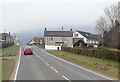
Entering Meigh on the B113 (Forkill Road)
The mountain in the background, half hidden by the mist, is Slieve Gullion.
Image: © Eric Jones
Taken: 9 Apr 2018
0.09 miles
9
The Tobar Blinne Estate on the west side of Chapel Road, Meigh
The village of Meigh has become a dormitory village for commuters to nearby Newry which is some 7km away. Slieve Gullion forms the background.
Image: © Eric Jones
Taken: 11 Apr 2014
0.09 miles
10
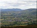
The South Armagh village of Meigh
The village is located on the Plain of Meigh a short distance north of the Gap o' the North through which the A1/N1 and the East Coast Railway line are channelled. The Plain is bounded on its east and south east side by hills of the Ring of Gullion. The eastern slopes of these hills descend steeply down to the Newry River valley and Carlingford Lough, beyond which are the Mourne Mountains.
https://en.wikipedia.org/wiki/Meigh
Image: © Eric Jones
Taken: 21 Jun 2018
0.09 miles