IMAGES TAKEN NEAR TO
Drumilly Road, NEWRY, BT35 7QF
Introduction
This page details the photographs taken nearby to Drumilly Road, BT35 7QF by members of the Geograph project.
The Geograph project started in 2005 with the aim of publishing, organising and preserving representative images for every square kilometre of Great Britain, Ireland and the Isle of Man.

There are currently over 7.5m images from over14,400 individuals and you can help contribute to the project by visiting https://www.geograph.org.uk
Image Map
Images are licensed for reuse under creativecommons.org/licenses/by-sa/2.0
Notes
- Clicking on the map will re-center to the selected point.
- The higher the marker number, the further away the image location is from the centre of the postcode.
Image Listing (9 Images Found)
Images are licensed for reuse under creativecommons.org/licenses/by-sa/2.0
Image
Details
Distance
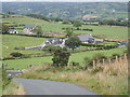
1
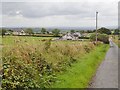
Recently built houses along the Drumilly Road
Image: © Eric Jones
Taken: 20 Aug 2019
0.01 miles
2
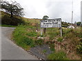
Road name plate at the western end of Drumilly Road
Image: © Eric Jones
Taken: 20 Aug 2019
0.10 miles
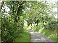
3
Private road leading South from the Drumilly Road
This serves two new houses.
Image: © Eric Jones
Taken: 20 Aug 2019
0.11 miles
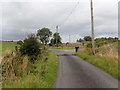
4
The Drumilly Road junction on the Barr Road
The Barr Road continues due North to join the A25 (Castleblayney-Stragford) Road, while the Drumilly Road travels ENE to join the B134 (Mountain Road).
Image: © Eric Jones
Taken: 20 Aug 2019
0.12 miles
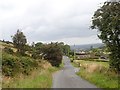
5
Steep descent on the Barr Road
Here, the Barr Road descends toward the T-junction with the Drumilly Road.
Image: © Eric Jones
Taken: 20 Aug 2019
0.16 miles
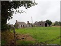
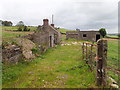
9
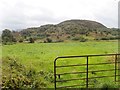
Grazing land between the Duburren Road and Courtney Mountain
Image: © Eric Jones
Taken: 20 Aug 2019
0.24 miles