IMAGES TAKEN NEAR TO
Tate Road, NEWRY, BT35 7PX
Introduction
This page details the photographs taken nearby to Tate Road, BT35 7PX by members of the Geograph project.
The Geograph project started in 2005 with the aim of publishing, organising and preserving representative images for every square kilometre of Great Britain, Ireland and the Isle of Man.

There are currently over 7.5m images from over14,400 individuals and you can help contribute to the project by visiting https://www.geograph.org.uk
Image Map
Images are licensed for reuse under creativecommons.org/licenses/by-sa/2.0
Notes
- Clicking on the map will re-center to the selected point.
- The higher the marker number, the further away the image location is from the centre of the postcode.
Image Listing (19 Images Found)
Images are licensed for reuse under creativecommons.org/licenses/by-sa/2.0
Image
Details
Distance
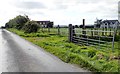
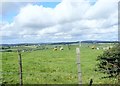
1
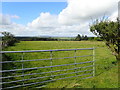
Grazing land on the West side of Tate Road
On rising ground in the background is the large forest known as the Fews Forest which lies north-east of Keady.
Image: © Eric Jones
Taken: 12 Sep 2018
0.03 miles
2
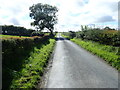
View South along Tate Road
Tate Road links the A25 (Newtownhamilton Road) with the B30 (Newry Road)
Image: © Eric Jones
Taken: 12 Sep 2018
0.06 miles
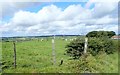
3

Footpath along the edge of a field
This private path leads east towards Shaughans Road. The summit ridge of Slieve Gullion can be seen in the background.
Image: © Eric Jones
Taken: 12 Sep 2018
0.08 miles
5
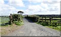
Private farm lane linking Tate Road and Shaughan Road
Image: © Eric Jones
Taken: 12 Sep 2018
0.11 miles
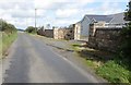
6
A pair of recently built houses on the West side of Tate Road
Ribbon development is an ubiquitous feature of the Irish rural landscape in both jurisdictions.
Image: © Eric Jones
Taken: 12 Sep 2018
0.12 miles
7
Cattle grazings on the west side of Tate Road
Image: © Eric Jones
Taken: 12 Sep 2018
0.14 miles
8
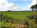
View West across pasture land for the Tate Road
Beyond is the Carrickrovaddy Forest.
Image: © Eric Jones
Taken: 12 Sep 2018
0.15 miles
9
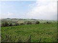
Rolling country side in the upper Forkhill River valley
Tate Road runs north-south along the summit of the ridge in the background.
Image: © Eric Jones
Taken: 12 Sep 2014
0.15 miles
10
Cattle grazing on the west side of Tate Road
The wind turbine in the middle ground is above the A25/Carrickrovaddy Road junction.
Image: © Eric Jones
Taken: 12 Sep 2018
0.16 miles