IMAGES TAKEN NEAR TO
Newtown Road, NEWRY, BT35 7PP
Introduction
This page details the photographs taken nearby to Newtown Road, BT35 7PP by members of the Geograph project.
The Geograph project started in 2005 with the aim of publishing, organising and preserving representative images for every square kilometre of Great Britain, Ireland and the Isle of Man.

There are currently over 7.5m images from over14,400 individuals and you can help contribute to the project by visiting https://www.geograph.org.uk
Image Map
Images are licensed for reuse under creativecommons.org/licenses/by-sa/2.0
Notes
- Clicking on the map will re-center to the selected point.
- The higher the marker number, the further away the image location is from the centre of the postcode.
Image Listing (7 Images Found)
Images are licensed for reuse under creativecommons.org/licenses/by-sa/2.0
Image
Details
Distance
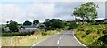
1
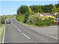
Shelter belt around a bungalow on the A25
The bungalow is located between the Carrickrovaddy Road junction and the Outleckan Road junction.
Image: © Eric Jones
Taken: 7 Jun 2019
0.01 miles
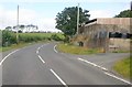
2
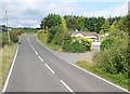
Bungalow on the A25 east of Outleckan Road
Image: © Eric Jones
Taken: 8 Aug 2019
0.02 miles
3
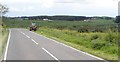
Farmer feeding cattle in field on the south side of the A25
Carrickrovaddy Wood forms the background.
Image: © Eric Jones
Taken: 7 Jun 2019
0.05 miles
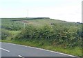
4
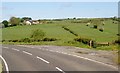
Drumlin above the A25 west of Magee Terrace
An inter-drumlin wetland lies between the road and the drumlin.
Image: © Eric Jones
Taken: 7 Jun 2019
0.08 miles
5
Farm houses and outbuildings at Magenis Cross Roads
These are located roughly half way between Belleek and Newtownhamilton
Image: © Eric Jones
Taken: 8 Aug 2019
0.15 miles
7
Land reclamation on hill slope between the Newry Road and Carrickrovaddy Road
The wind turbine is also a recent addition.
Image: © Eric Jones
Taken: 8 Aug 2019
0.22 miles